 文字サイズ
文字サイズReconstruction Seen from the Air
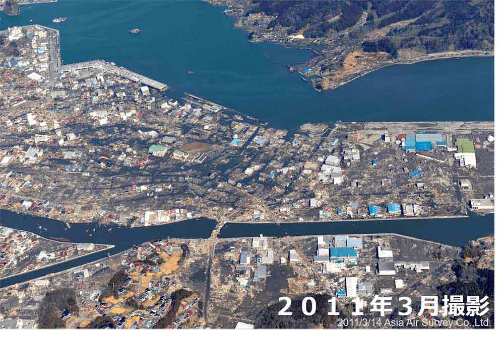
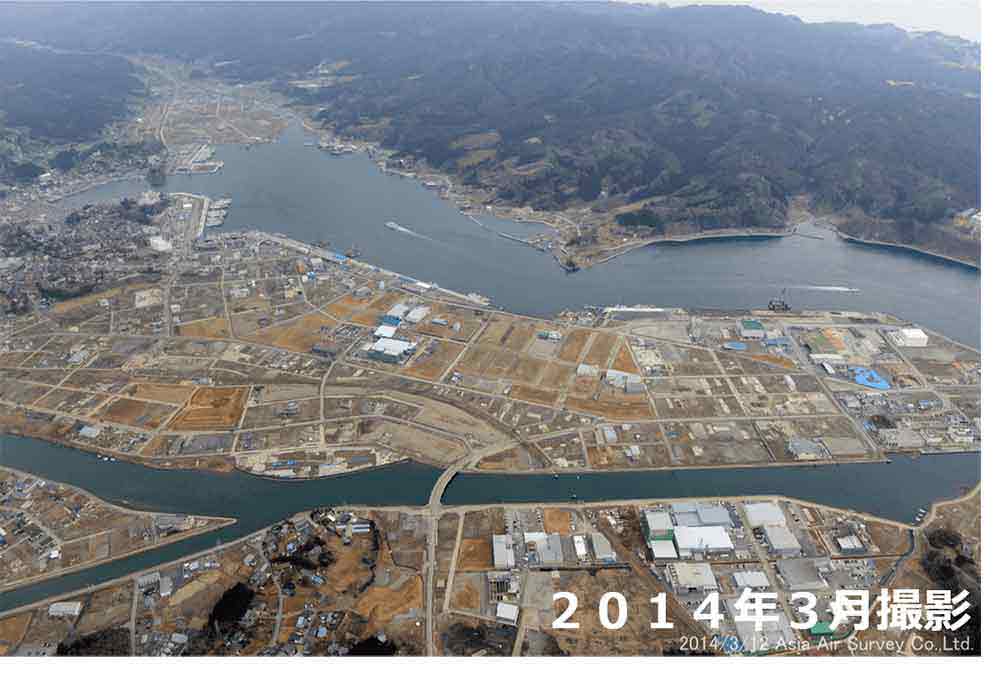
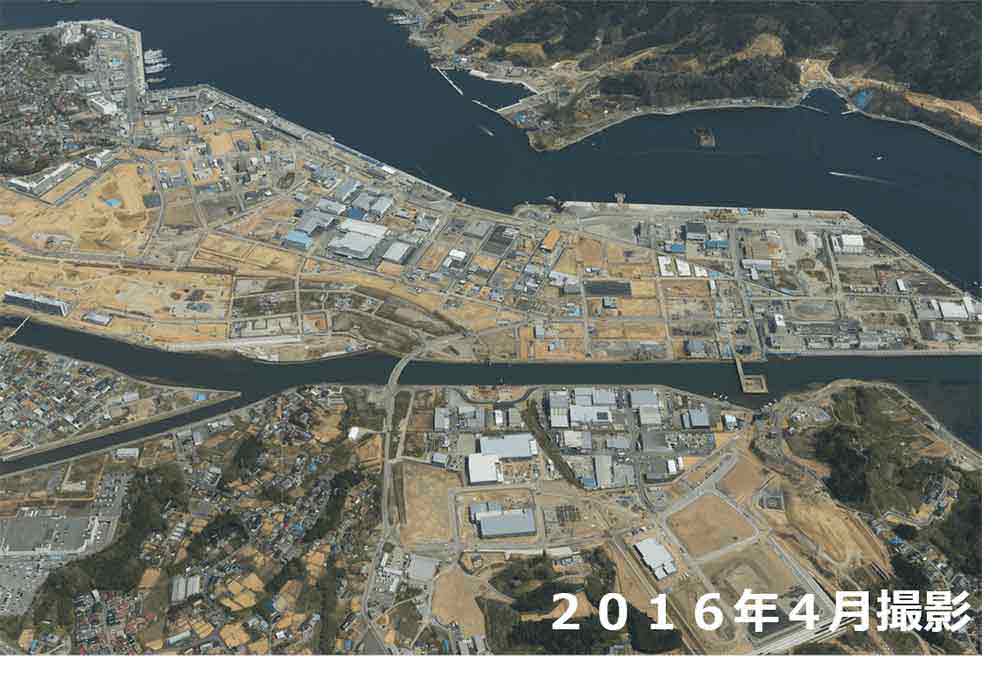
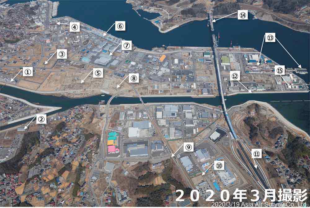
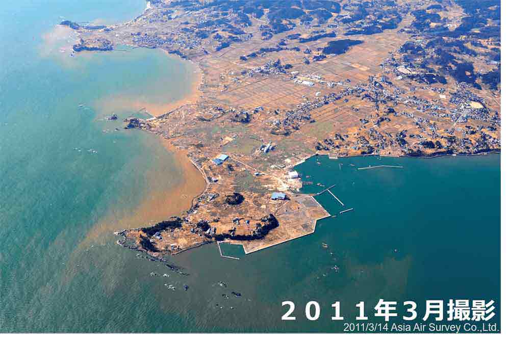
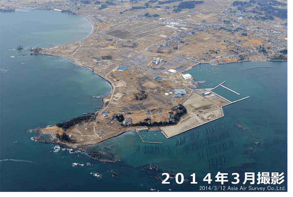
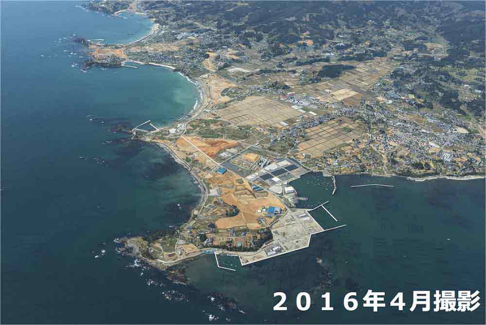
See the affected region, as it was in the immediate aftermath and as it is today, in aerial photographs.
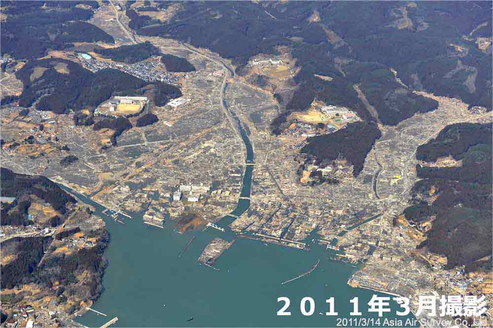
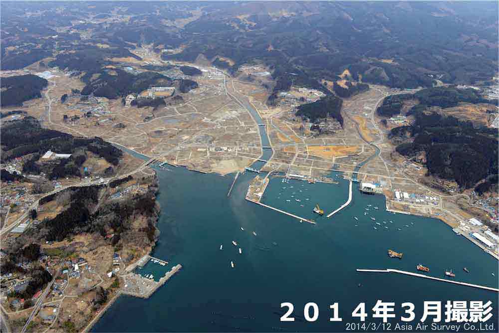
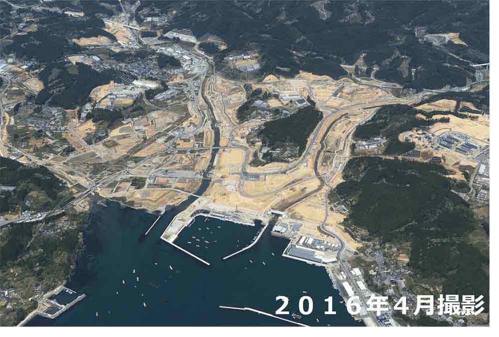
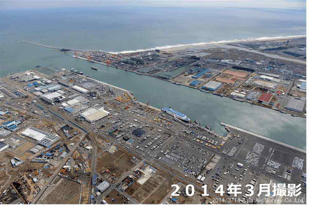
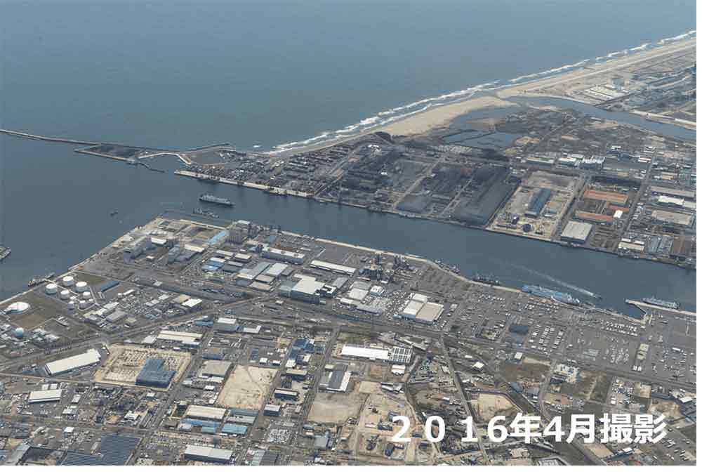
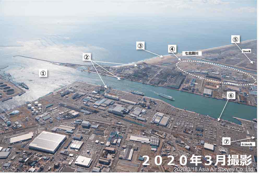
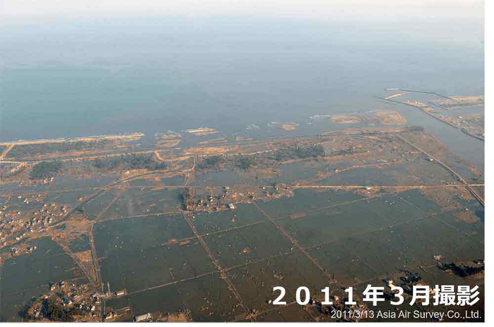
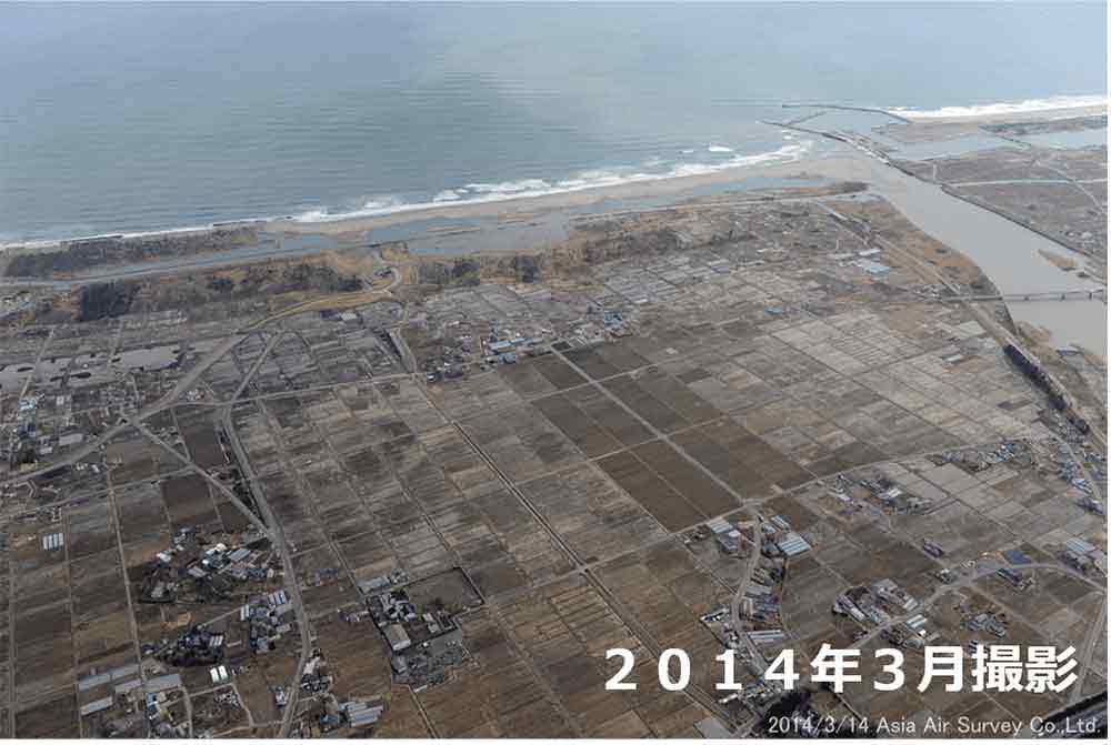
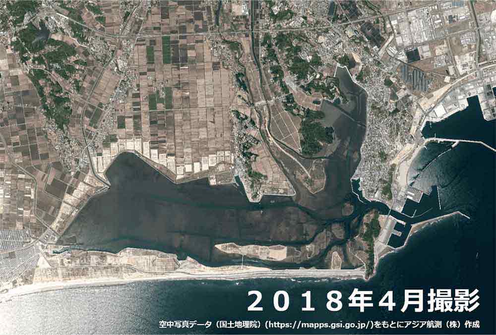
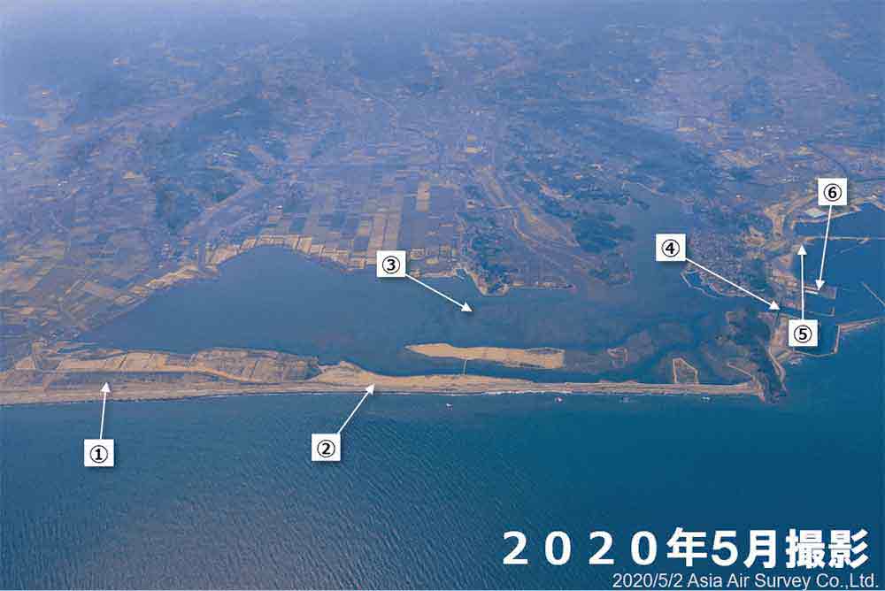
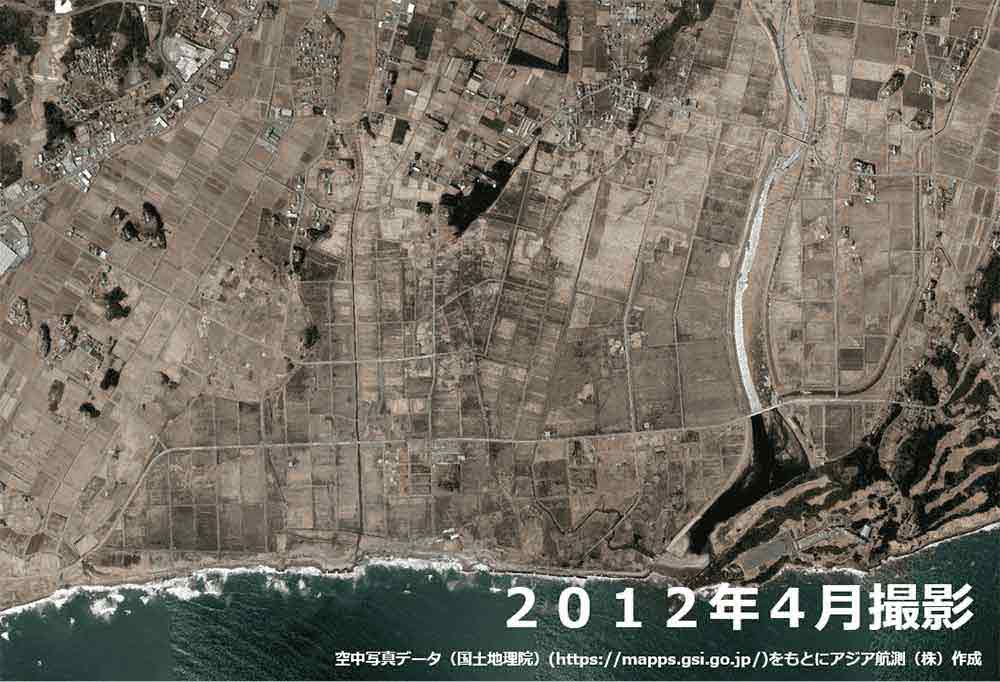
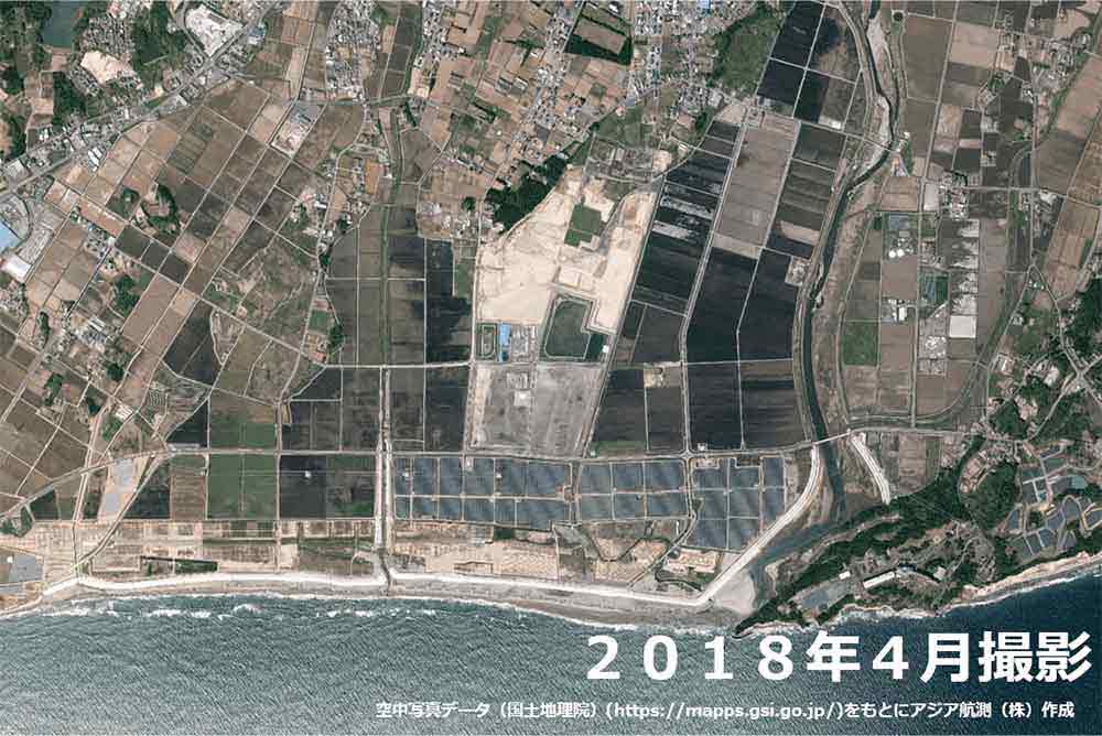
Images taken in Iwate and Miyagi Prefectures in 2011, 2014, and 2020, were provided by Asia Air Survey Co., Ltd.
Images of Fukushima Prefecture were either photographed by Asia Air Survey Co., Ltd., or prepared by Asia Air Survey Co., Ltd. using aerial photographic data from the Geographical Survey Institute (https://mapps.gsi.go.jp/).
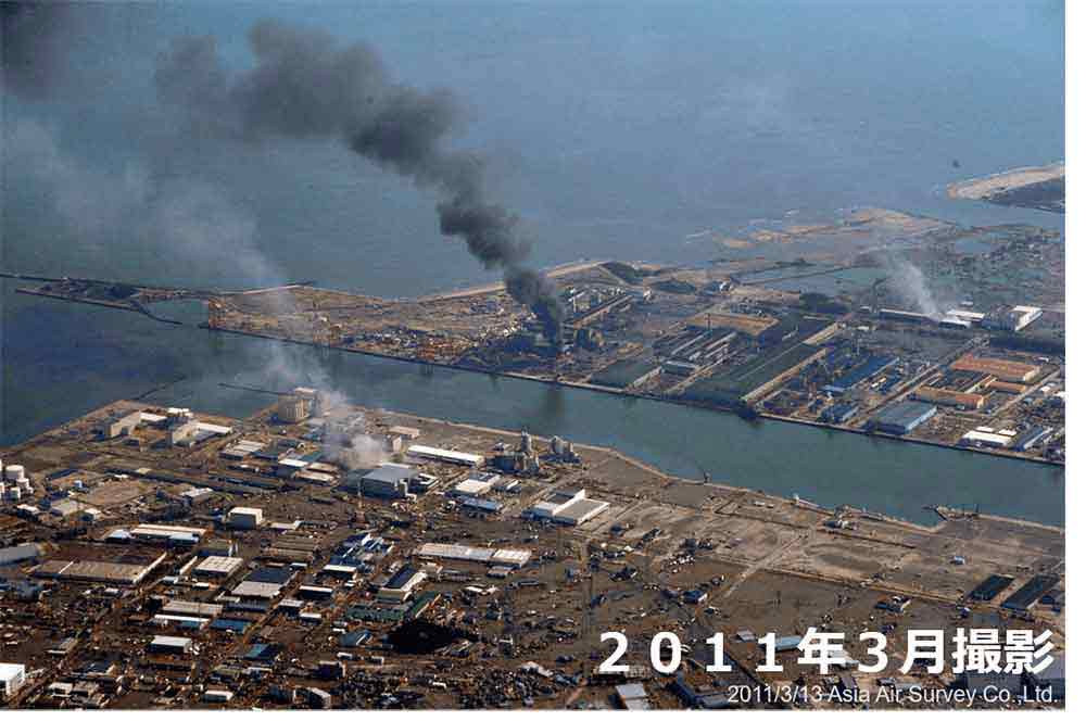
As part of its CSR activities, Asia Air Survey Co., Ltd. took aerial photographs of affected areas from the day after the Great East Japan Earthquake, which it has published on its website and provided to related regional authorities etc.
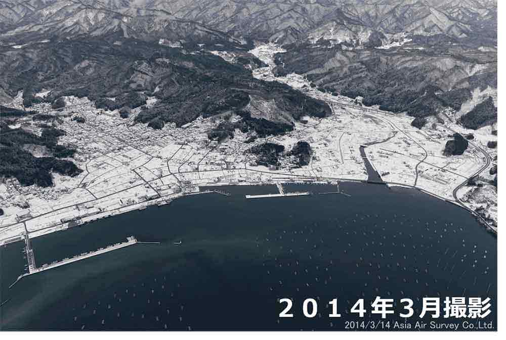
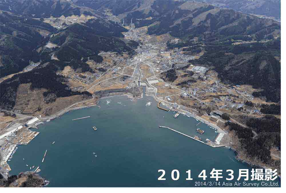
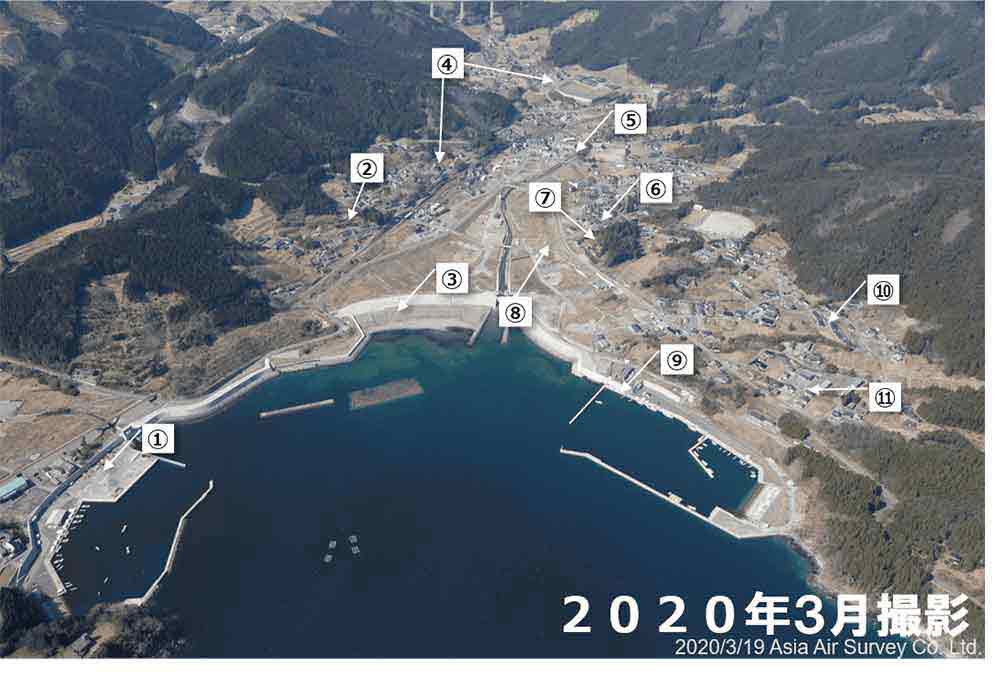
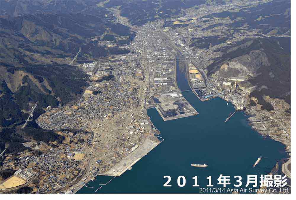
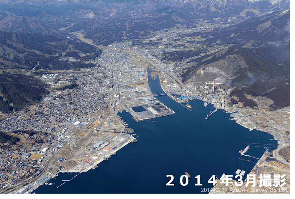
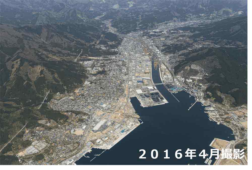
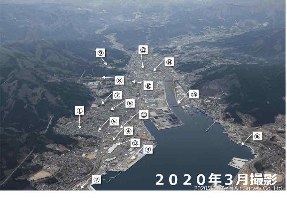
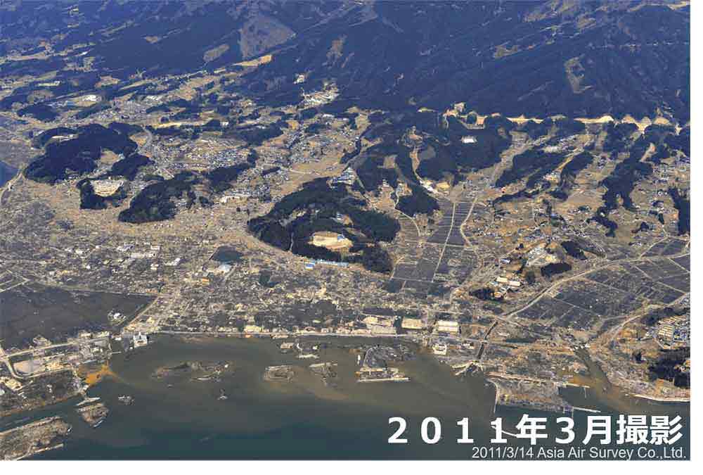
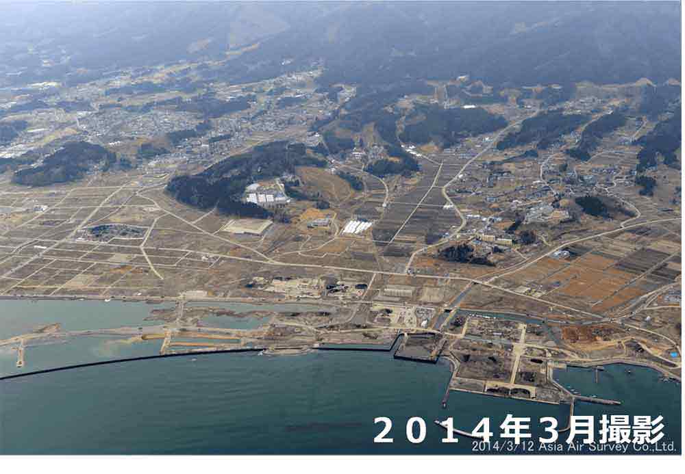
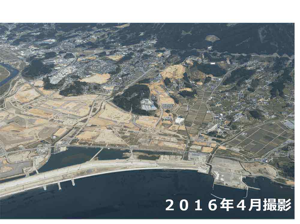
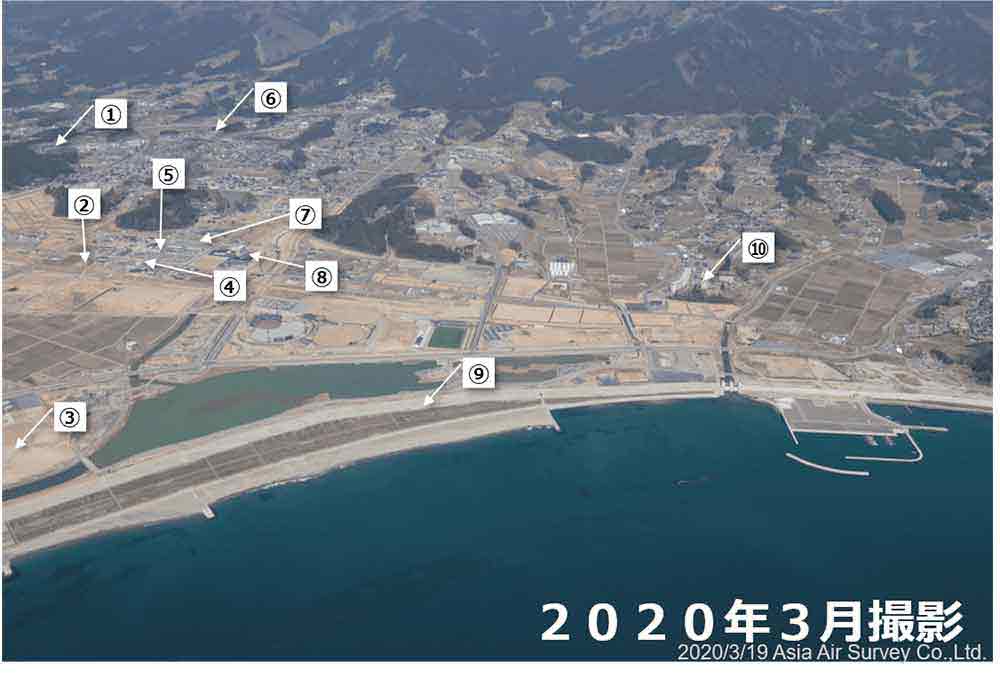
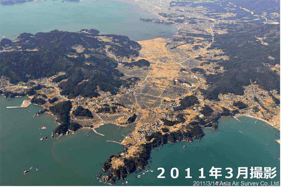
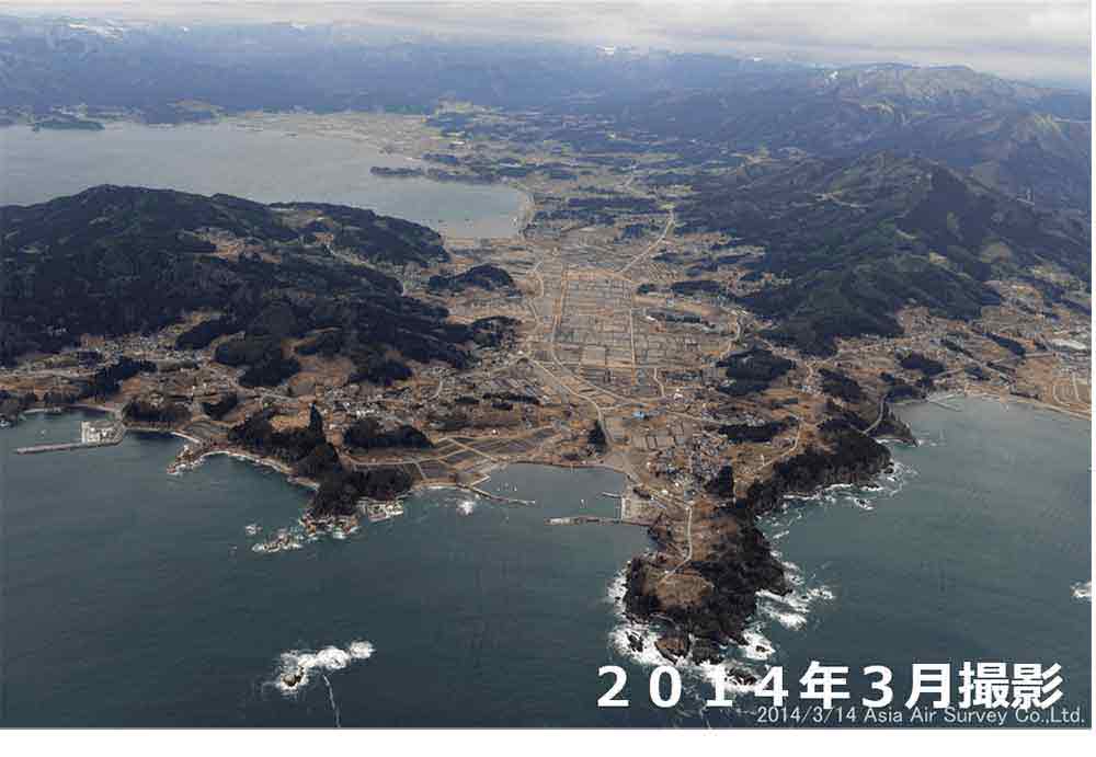
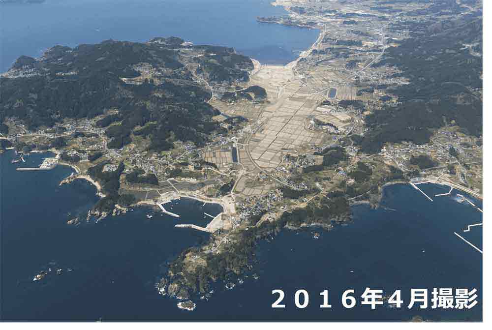
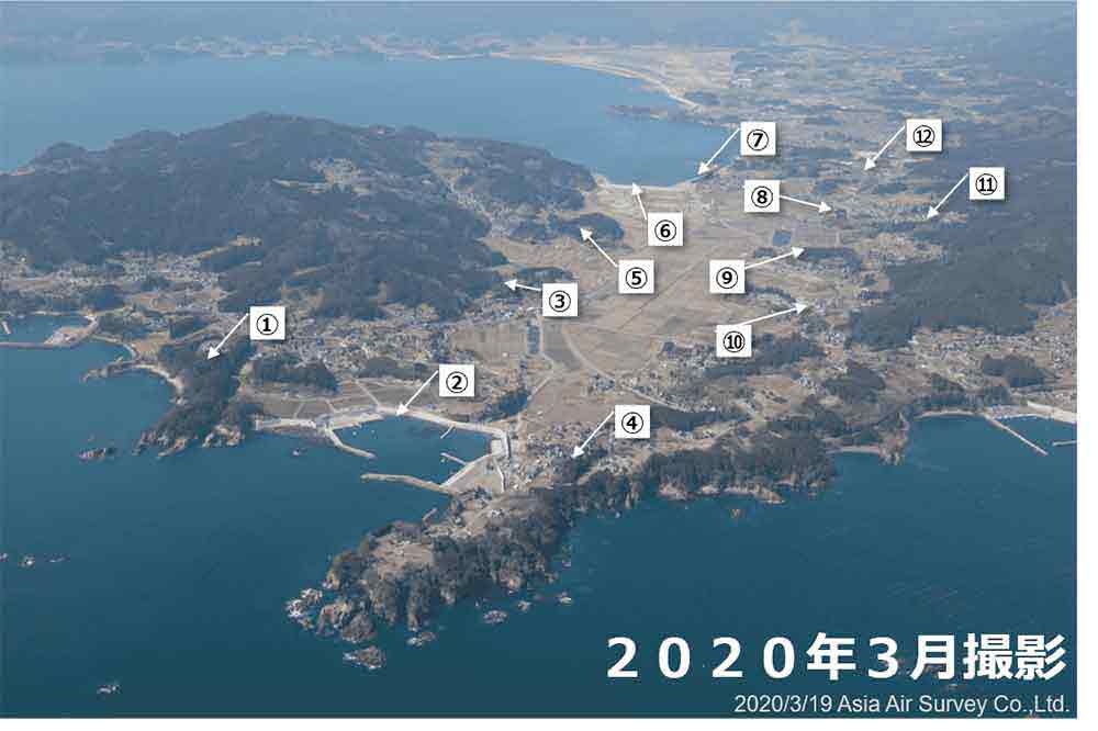
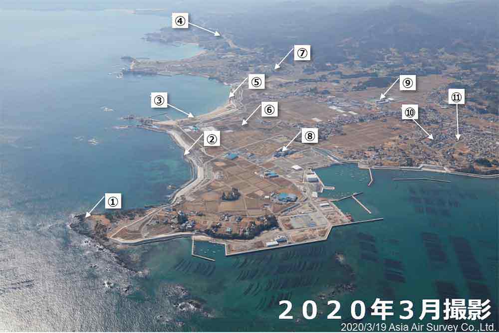
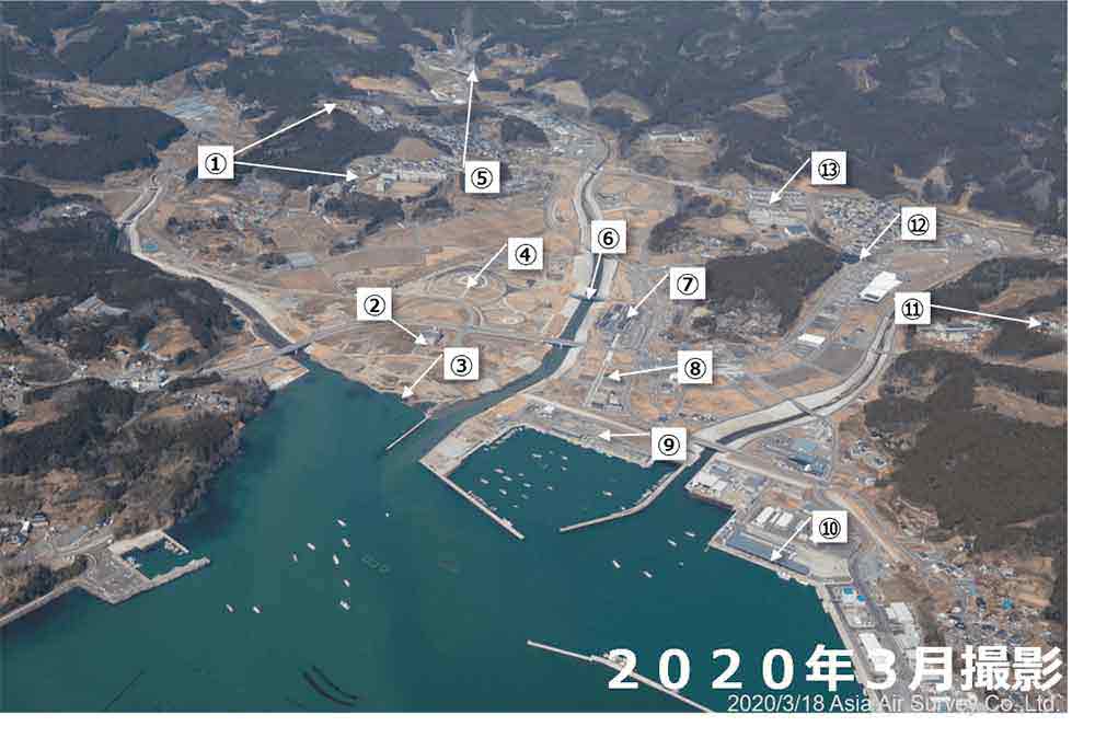
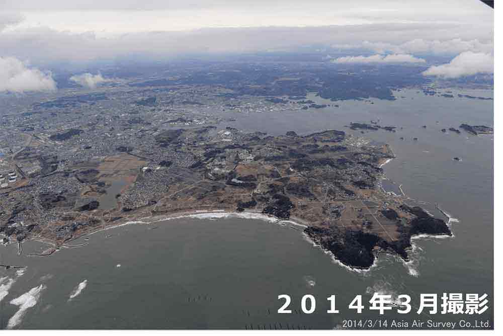
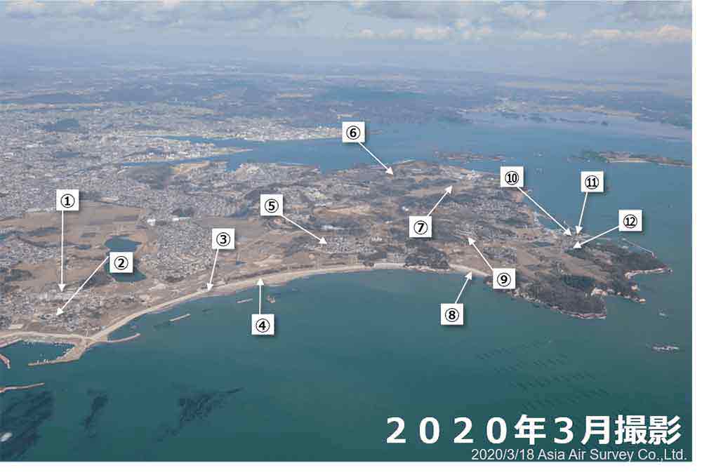
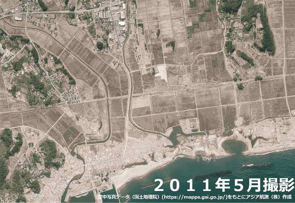
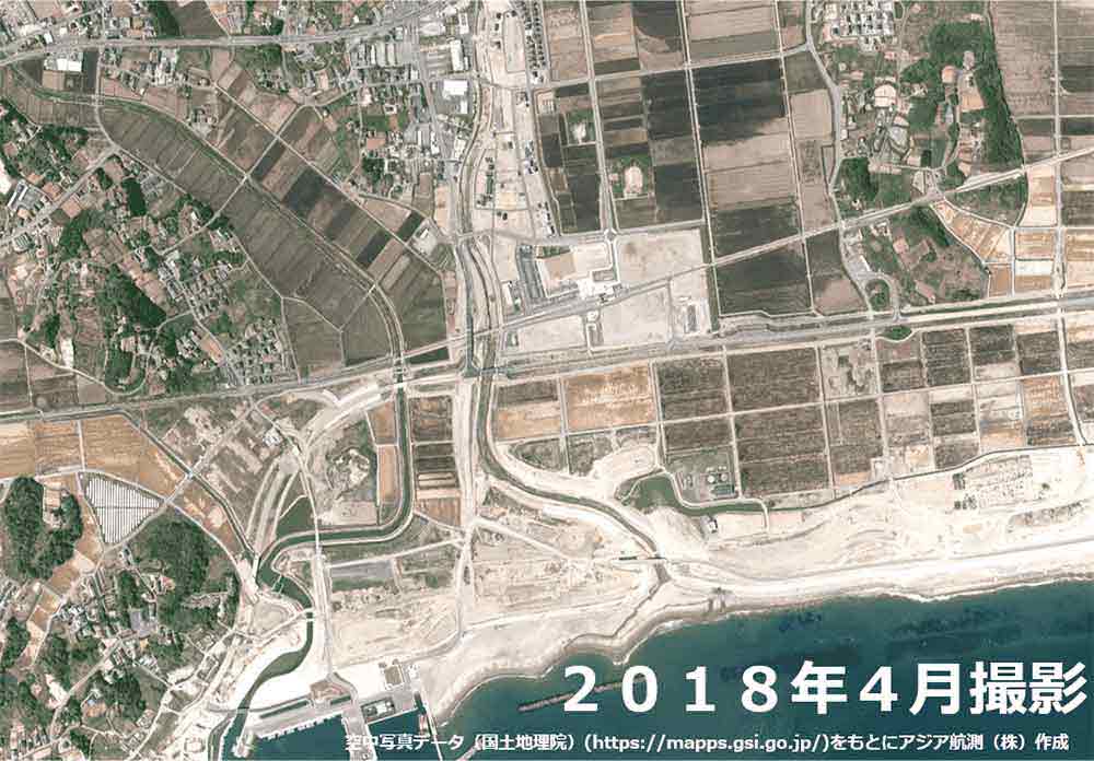
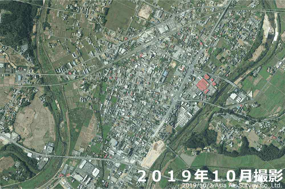
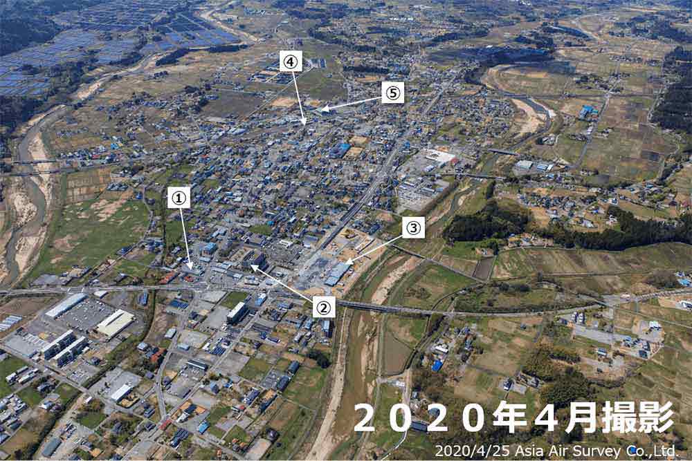
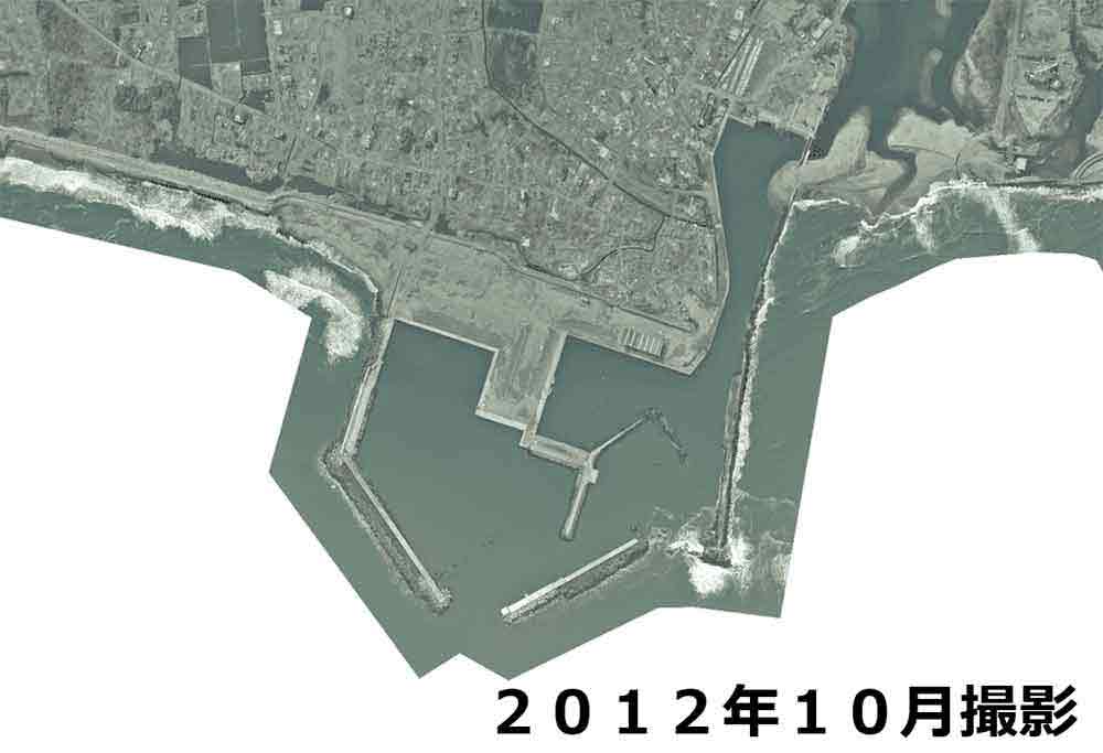
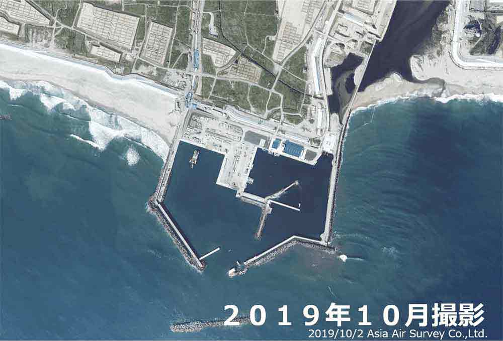
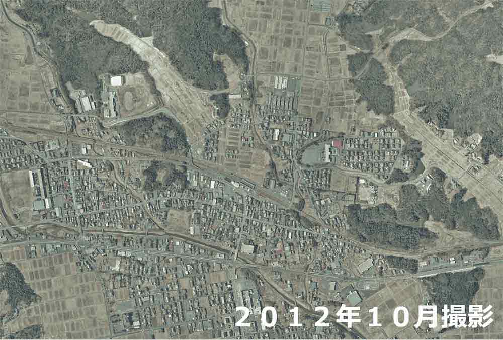
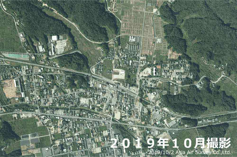
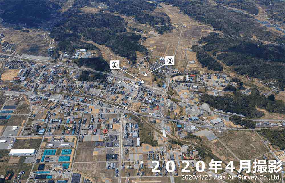
Iwate Prefecture

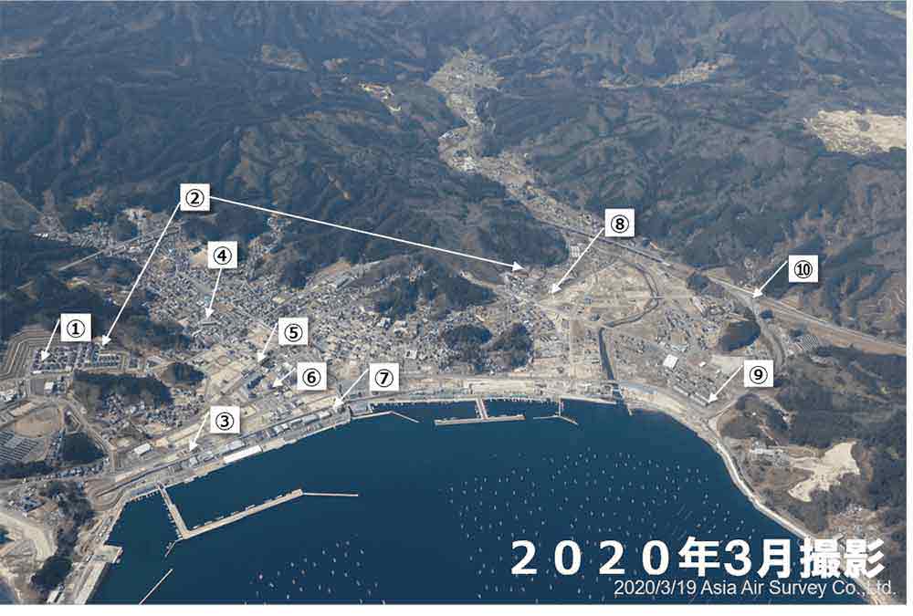
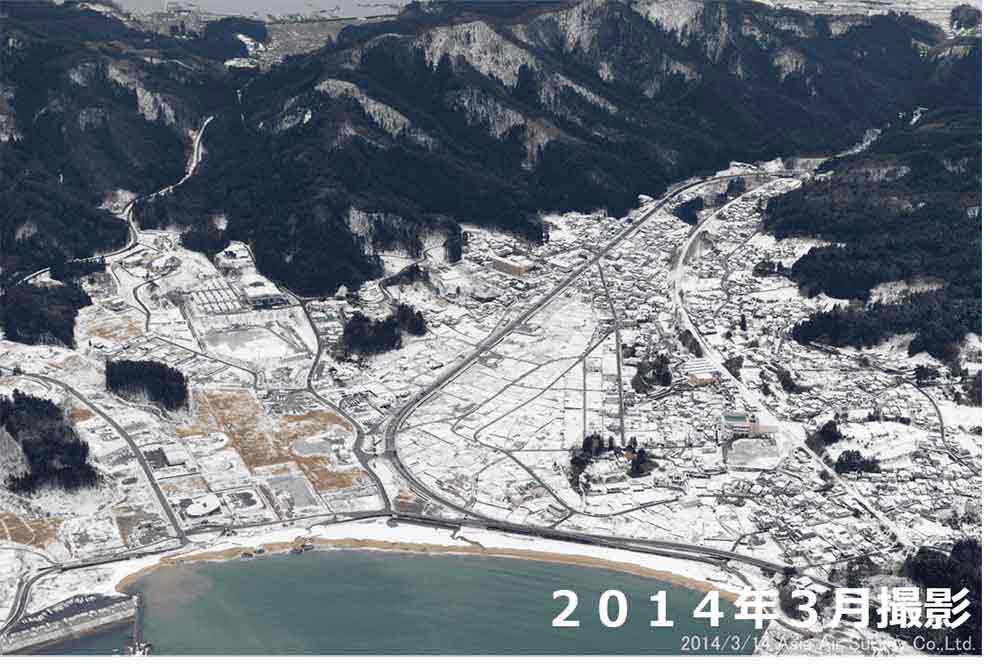
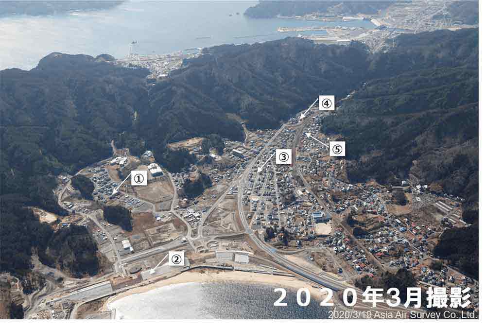
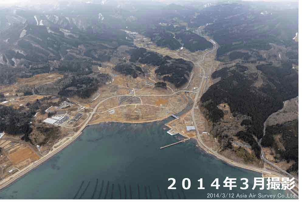
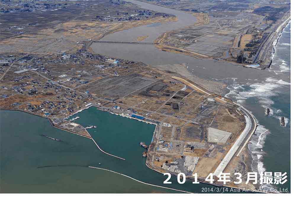
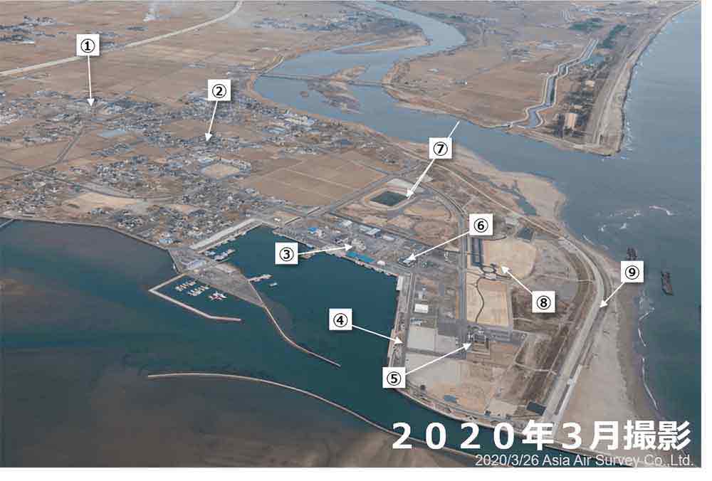
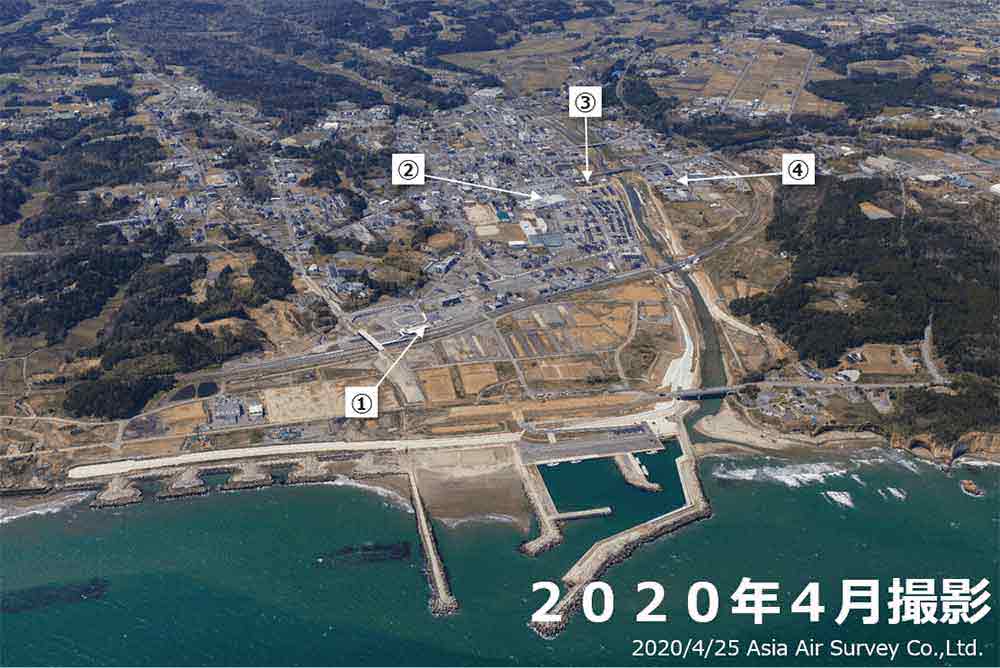
Miyako City
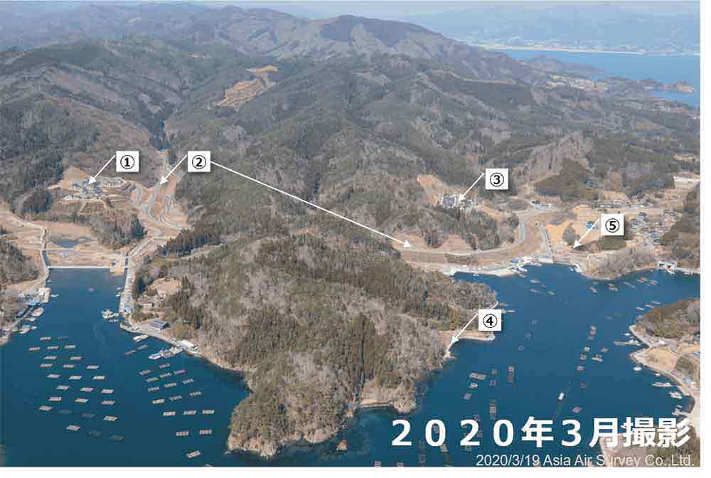
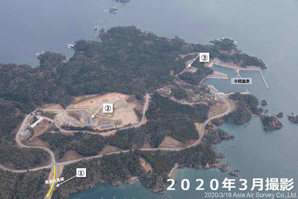
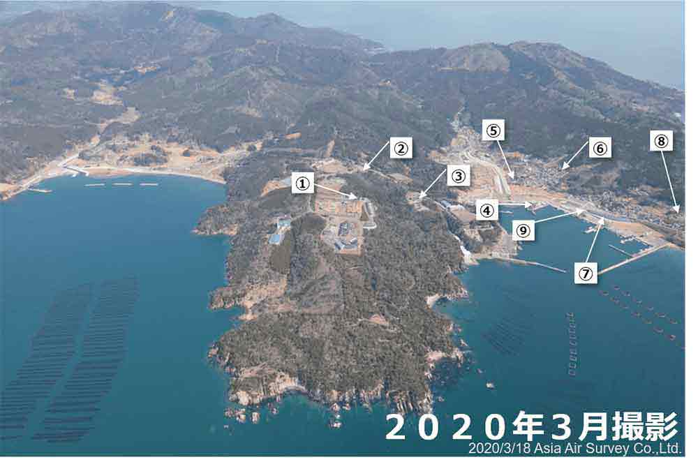
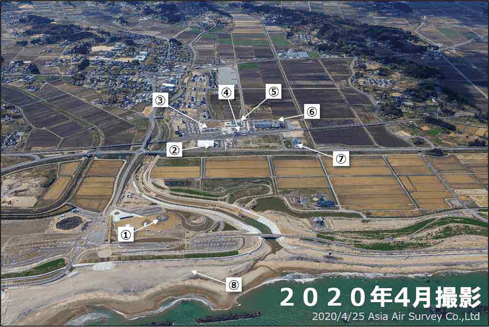
Taro Area, Miyako City
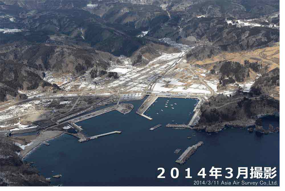

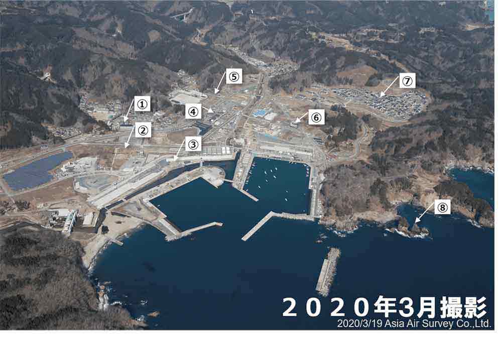
- Disaster public housing (Taro District)
- Completed in November 2015. 40 houses.
- Seawall (Taro Coast) (Secondary levee)
- Completed in November 2017. Height: 10.0 m / Length: 1.0 km
- Seawall (Coast around Taro Fishery Port) (Primary levee)
- To be completed in 2020.
Height: 14.7 m / Length: 1.2 km - Roadside Station Taro
- Opened fully in April 2018.
Recognized as a ""Key Roadside Station."" It is positioned as a gateway to the Sanriku Geopark where residents can interact and participate in activities. - Land readjustment project (Taro District)
- Completed in March 2016. 180 houses.
- Taro Kanko Hotel
- Opened as a tsunami heritage site in April 2016.
Shows video footage of the tsunami taken from the sixth floor of the hotel at the time of the earthquake to visitors at events such as the tourism board's Disaster Prevention Learning Tour. - Collective relocation for disaster prevention (Taro District)
- Completed in September 2015. 159 houses.
Disaster public housing (Taro District (hillside))
Completed in March 2016. 71 houses. - Sannoiwa
- A 50-meter high rock, commonly known as the male rock, is flanked by a female rock and a drum-shaped rock. It is the most stunning of the many oddly shaped rocks in Sanriku Fukko (reconstruction) National Park.
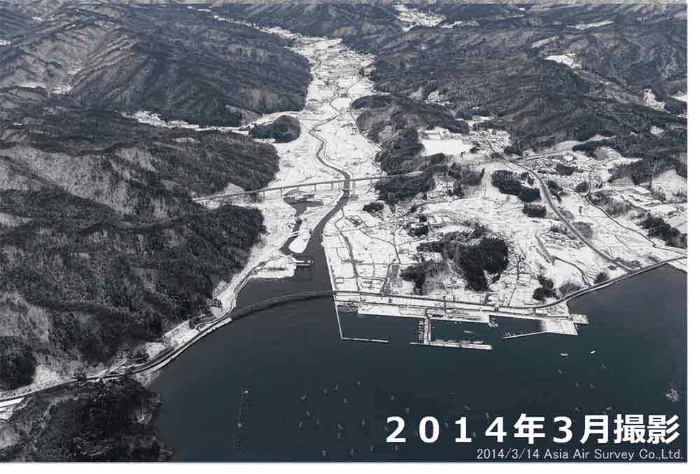
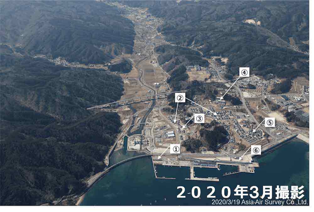
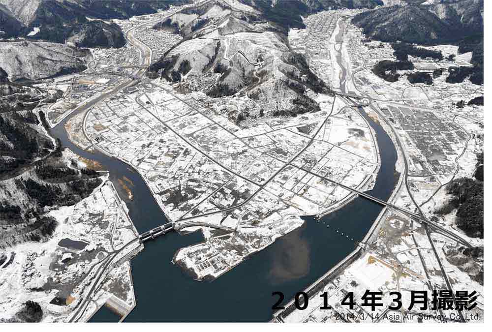
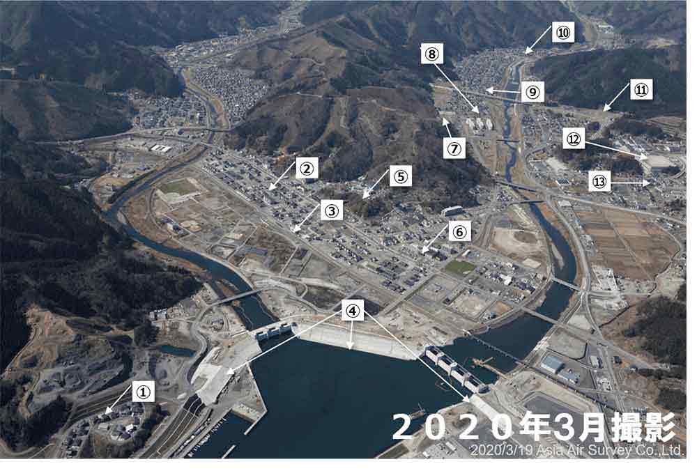
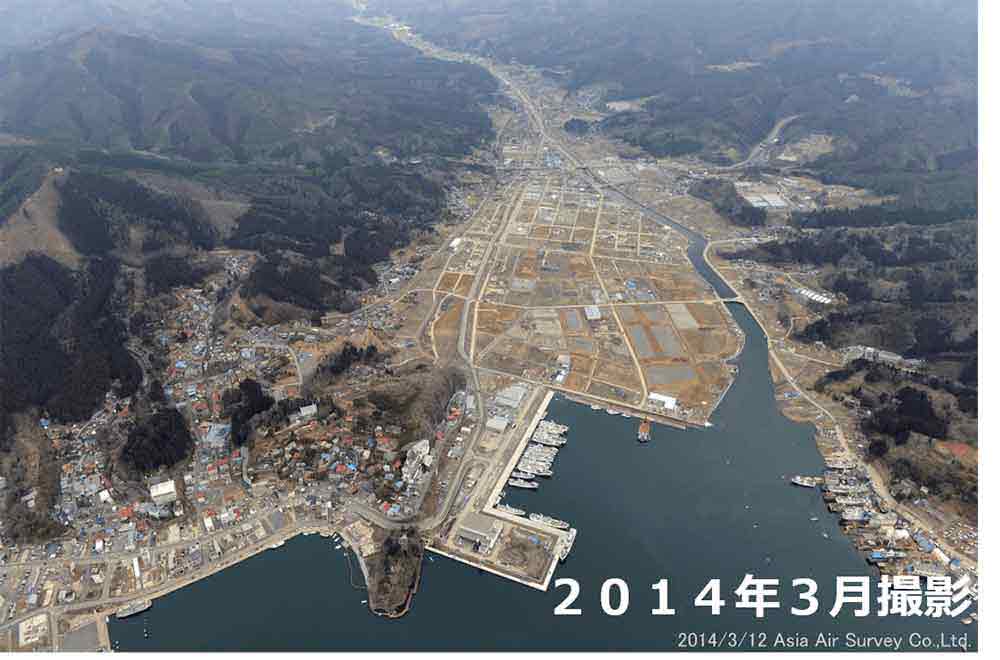
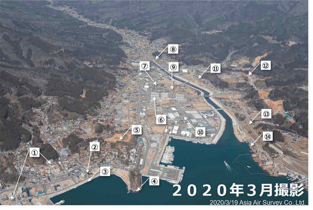
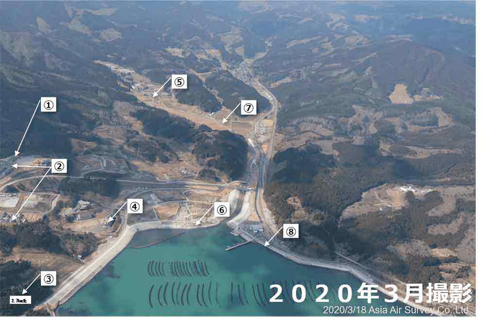
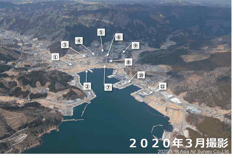
Kuwagasaki and Koganji Area, Miyako City
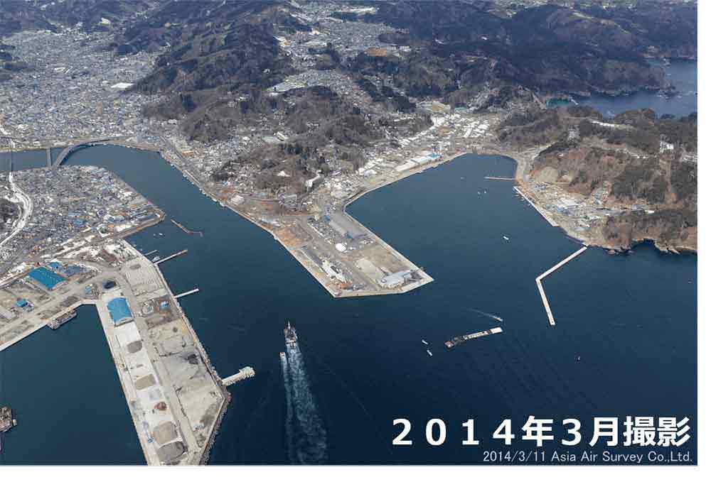
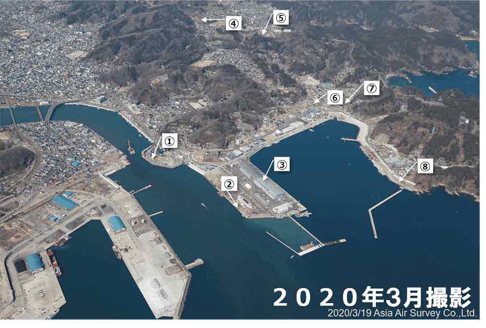
- Hei River Floodgate
- To be completed in 2026.
- Seatopia Nado (Roadside Station Miyako)
- Reopened in July 2013.
Fresh fish, shellfish, and delicacies from the mountain villages are available in the produce sales area, and the information area has up-to-date information about the roads along the Rikuchu Coast and information about local attractions. - Miyako City Fish Market
- Completed in March 2016.
The sorting facilities of the fish market was expanded. - Disaster public housing (Hinode-cho)
- Completed in April 2015. 26 houses.
- Disaster public housing (Sabara)
- Completed in February 2015. 50 houses.
- Land readjustment project (Kuwagasaki and Koganji District)
- Completed in March 2018. 230 houses
- Disaster public housing (Minato-cho)
- Completed in December 2015. 40 houses.
- Seawall (Coast around Miyako Port (Kuwagasaki))
- Completed in September 2019.
Height: 10.4 m / Length: 1.6 km
Yamada Town
Yamada Area, Yamada Town
- Disaster public housing (Iioka)
- Completed in December 2018. 36 houses.
- Collective relocation for disaster prevention (Yamada District)
- Completed in December 2018. 93 houses.
- Seawall (Coast around Yamada Fishery Port)
- To be completed in 2020. Height: 9.7 m / Length: 1.6 km
- Disaster public housing (Second Nagasaki)
- Completed in February 2018. 50 houses.
- Rikuchuyamada Station
- Reopened in March 2019 as a station on the Rias line of the Sanriku Railway. The nickname of the
station is "Dutch Island of the Sea." The station building has a western style design that resembles a
Dutch island and a windmill.
Hapine (Yamada Town Fureai Center)
"Opened in July 2016. A public facility that combines the functions of a library and a space for elementary, middle school, and high school students."
Machinaka Exchange Center
"Opened in November 2016. A vibrant exchange center that serves as a gathering place for city residents and a venue for exchange activities to re-energize the community by promoting local vitality." - Land readjustment project (Yamada District)
- Completed in February 2019. 473 houses.
Disaster public housing (Yamada Chuo)
Completed in September 2016. 146 houses. - Land readjustment project (District around National Route 45 in Yamada District)
- Completed in September 2019.
- Disaster public housing (Kitahama)
- Completed in October 2016. 72 houses.
- Disaster public housing (Yanagisawa)
- Completed in April 2015. 49 houses.
- Yamada Interchange, Sanriku Expressway
- 120 min drive from Morioka City.
The sector between Yamada IC and Miyako Minami IC opened in November 2017.
Orikasa Area, Yamada Town
- Seawall (Coast around Orikasa Fishery Port)
- Completed in November 2019. Height: 9.7 m / Length: 1.4 km
- Collective relocation for disaster prevention (Orikasa District)
- Completed in May 2016. 47 houses.
- Land readjustment project (Orikasa District)
- Completed in May 2016. 148 houses.
- Disaster public housing (Tsumanokami)
- Completed in October 2015. 52 houses.
- Disaster public housing (Orikasa Atohama)
- Completed in November 2015. 22 houses.
- Land readjustment project (Orikasa District (Atohama area))
- To be completed in 2020.
Otsuchi Town
Kirikiri Area, Otsuchi Town
- Collective relocation for disaster prevention (The second apartment of Kirikiri District)
- Completed in September 2016. 35 houses.
- Seawall (Coast around Kirikiri Fishery Port)
- Completed in October 2020. Height: 12.8 m / Length: 0.9 km
- Land readjustment project (Kirikiri District)
- Completed in December 2017. 200 houses.
Disaster public housing (Kirikiri)
Completed in October 2017. 19 houses. - Collective relocation for disaster prevention (The third apartment of Kirikiri District)
- Completed in March 2016. 13 houses.
- Collective relocation for disaster prevention (The first apartment of Kirikiri District)
- Completed in July 2015. 18 houses.
Machikata Area, Otsuchi Town
- Collective relocation for disaster prevention (Komakura apartment)
- Completed in November 2016. 22 houses.
- Land readjustment project (Machikata District)
- Completed in November 2017. 510 houses.
Collective relocation for disaster prevention (Machikata District)
Completed in December 2017. 35 houses.Disaster public housing (Machikata District)
All public housing houses for disaster victims in the zoning district were completed in March 2019. 277 houses in total. - Otsuchi Station
- The circular design resembles Hyotan Island (Horai Island).
- Seawall (Otsuchi River, Kotsuchi River, Otsuchi Fishery Port)
- Completed in March 2020.
Height: 14.5 m / Total length: 2.6 km - Shiroyama Park
- Highly appreciated by the public as a picturesque place overlooking Otsuchi. The flame of hope was lit from a flame in Kobe where the Great Hanshin Earthquake occurred.
- Oshacchi (Otsuchi Town Cultural Exchange Center)
- Opened in June 2018.
The facility combines the library and the Oshachi Exchange Center that were located near Oshachi, the center of Otsuchi town, before the earthquake. - Collective relocation for disaster prevention (Ogakuchi and Yashikimae apartments)
- Completed in November 2016. 11 houses.
- Disaster public housing (Yashikimae by Otsuchi Town)
- Completed in November 2013. 21 houses.
- Disaster public housing (Ogakuchi)
- Completed in August 2013. 70 houses.
- Disaster public housing (Ogakuchi 2-chome)
- Completed in September 2014. 23 houses.
- Otsuchi Interchange, Sanriku Expressway
- 125 min drive from Morioka City. The section between Otsuchi IC and Yamada Minami IC opened in January 2019. The section between Kamaishi Kita IC and Otsuchi IC opened in June 2019.
- Disaster public housing (Yashikimae by Iwate Pref.)
- Completed in October 2015. 151 houses.
- Collective relocation for disaster prevention (Sawayama and Natsumoto apartments)
- Completed in November 2016. 34 houses.
Kamaishi City
Katagishi and Unosumai Area, Kamaishi City
- Land readjustment project (Unosumai District)
- Completed in March 2019. 529 houses.
Disaster public housing (Unosumai District)
All public housing houses for disaster victims in the zoning district were completed in September 2017. 120 houses in total. - Kamaishi Unosumai Memorial Stadium
- Completed in July 2018.
Kamaishi City's symbol of reconstruction.
One of the stadiums hosted Rugby World Cup 2019. - Unosumai Tomosu
- Opened in March 2019.
Kamaishi Memorial Park Earthquake Memorial,
Tsunami Memorial Hall Disaster Prevention Learning Facility,
Unosato Visitor Center Tourism Visitor Base. - Seawall (Katagishi Coast)
- Completed in December 2018.
Height: 14.5 m / Length: 0.8 km - Disaster public housing (Katagishi by Iwate Pref.)
- Completed in February 2017. 17 houses.
- Land readjustment project (Katagishi District)
- Completed in March 2019. 190 houses.
Disaster public housing (Katagishi by Kamaishi City.)
Completed in August 2017. 18 houses. - Kamaishi Kita Interchange, Sanriku Expressway
- 105 min drive from Morioka City.
The section between Kamaishi Kita IC and Otsuchi IC opened in June 2019.
Eastern Area, Kamaishi City
- Seawall (Coast around Ureishi Fishery Port)
- Completed in September 2019.
Height: 6.1 m / Length: 0.5 km - Seawall (Coast around Kamaishi Port)
- Completed in March 2018.
Height: 6.1 m / Length: 2.1 km - Land readjustment project (Ureishi and Matsubara District)
- Completed in December 2017. 179 houses.
Disaster public housing (1st and 2nd Ureishi, Matsubara)
All public housing houses for disaster victims in the zoning district were completed in July 2017. 144 houses in total. - Seawall (Coast around Kamaishi Port)
- To be completed in 2020.
Height: 6.1 m / Length: 1.9 km - UOGASHI terrace
- Opened in April 2019.
At Seaside Town, Kamaishi, you can enjoy looking out over Kamaishi Bay while eating locally sourced ingredients. - Disaster public housing (Central-eastern area)
- All public housing houses for disaster victims in the central area were completed in December 2018. 378 houses in total.
- TETTO (Kamaishi City Civic Hall)
- Opened in October 2017.
The word ""tetto"" comes from the word ""city of iron"" in Japanese, which represents Kamaishi's deep connection to iron, and the Italian word for ""roof." - Disaster public housing (Tenjin-cho)
- Completed in May 2016. 52 houses.
Ofunato City
Okirai Area, Ofunato City
- Seawall (Coast around Tomari Fishery Port)
- Completed in March 2017. Height: 11.5 m / Length: 0.3 km
- Collective relocation for disaster prevention (Urahama Minami District)
- Completed in December 2014. 11 houses.
- Seawall (Okirai Coast)
- Completed in March 2018. Height: 11.5 m / Length: 0.9 km
- Collective relocation for disaster prevention (Urahama Naka and Nishi District)
- Completed in December 2014. 10 houses.
- Disaster public housing (Urahama Tokorogayoi apartments)
- Completed in November 2015. 20 houses.
- Disaster protection for fishing communities (Okirai area)
- Completed in September 2017. 30 houses.
- Sanriku Daio Cedar
- The 7,000-year-old Daio cedar tree is said to be a living testament to the founding and history of the Okirai area. As a symbol of the region, it is carefully protected within the grounds of Hachiman Shrine.
- Dokonjo (Brave) Poplar
- A poplar tree that survived the Great East Japan Earthquake despite being hit by the tsunami.
- Seawall (Coast around Okirai Fishery Port)
- Completed in June 2019. Height: 11.5 m / Length: 0.3 km
- Disaster public housing (Urahama Sugishita apartments)
- Completed in March 2016. 9 houses.
- Collective relocation for disaster prevention (Urahama Higashi and Horei District)
- Completed in March 2015. 9 houses.
Ofunato Station Area, Ofunato City
- Disaster public housing (Tanaka Higashi apartments)
- Completed in March 2014. 19 houses.
- Ofunato City Fish Market
- Reopened with new facilities in April 2014. One of the world's leading fishing areas, Sanriku is the landing base for many seafood products. The facility offers a panoramic view of Ofunato Bay.
- Seawall (Coast around Nonoda District)
- To be completed in 2020. Height: 7.5 m / Length: 4.1 km
- Land readjustment project (Ofunato Station Area)
- Completed in March 2019. 231 houses.
Disaster public housing (land readjustment area)
Completed in July 2016. 50 houses. - Disaster public housing (Kawahara)
- Completed in May 2015. 29 houses.
- Disaster public housing (Kaminoyama apartments)
- Completed in April 2014. 11 houses.
- Disaster public housing (Akazawa apartments)
- Completed in June 2014. 23 houses.
- Collective relocation for disaster prevention (Ofunato District)
- Completed in May 2015. 18 houses.
- Disaster public housing (Utsunosawa apartments)
- Completed in May 2014. 20 houses.
- Disaster public housing (Shimotateshita)
- Completed in September 2016. 58 houses.
- Ofuna Port (Disaster Prevention Tourism Exchange Center)
- Opened in April 2018 A facility that offers services such as tourist information and products.
- Kyassen Ofunato
- Opened April 2017. A local commercial facility to eat, shop, and play.
- Disaster public housing (Sakari Chuo)
- Completed in December 2012. 44 houses.
- Disaster public housing (Midori-cho)
- Completed in March 2016. 147 houses.
- Seawall (Morikawa (Shioba))
- Completed in March 2019. Height: 7.5 m / Length: 2.3 km
- Seawall (Coast around Ofunato Port)
- To be completed in 2020. Height: 7.5 m / Length: 3.6 km
Rikuzentakata City
Takata Area, Rikuzentakata City
- Disaster public housing (Tochigasawa)
- Completed in June 2016. 301 houses.
- Land readjustment project (Takata District)
- To be completed in 2020. 986 houses.
Collective relocation for disaster prevention (Takata)
Completed in July 2018. 66 houses.Disaster public housing (Shimowano)
Completed in September 2014. 120 houses. - Takata Matsubara Tsunami Reconstruction Memorial Park
- Opened in September 2019.
As a national memorial and prayer site, it is a place to mourn and lay to rest the souls of the
victims of the Great East Japan Earthquake, to pass on the memories and lessons of the disaster, and
to instill a strong will to rebuild for people at home and abroad. There is a prayer area, a place
overlooking the sea, a place to lay flowers and a miracle single pine tree."
Roadside Station Takata Matsubara
Toilet and rest facilities, road and tourist information facilities, regional development facilities.Iwate Tsunami Memorial Museum
About 150 items, including earthquake heritage items, are on display. - Great East Japan Earthquake Memorial Facility
- The one-story wooden building is about 14 m2. There is a black granite tombstone inside. It is a
memorial for citizens and visitors following the earthquake.
Reconstruction Town Planning Information Hall
"Opened due to relocation in May 2018. A facility for citizens and visitors to deepen their understanding of town planning. Exhibits and dioramas are displayed showing what happened before and after the earthquake, during the emergency response, and during recovery and reconstruction." - Rikuzentakata City Library
- Opened in July 2017. Connected to Abasse Takata. There are about 65,000 books in the collection.
- Rikuzentakata Interchange, Sanriku Expressway
- 110 min drive from Morioka City. The section between Rikuzentakata IC and Kayooka IC opened in March 2014. The section between Rikuzentakata Osabe IC and Rikuzentakata IC opened in July 2018.
- Abasse Takata
- Opened in April 2017. A commercial facility to eat, shop, and play.
- The Miracle Single Pine Hall (Civic Culture Hall).
- Opened in April 2020. A 640-seat center for culture, the arts, and lifelong learning.
- Seawall (Takata Coast)
- Completed in December 2016. Height: 12.5 m / Length: 3.9 km
- Disaster public housing (Nakata)
- Completed in September 2015. 197 houses.
Hirota Area, Rikuzentakata City
- Collective relocation for disaster prevention (Nagahora)
- Completed in June 2014. 14 houses.
- Seawall (Coast around Tadaide Fishery Port)
- To be completed in 2020. Height: 12.8 m / Length: 0.8 km
- Collective relocation for disaster prevention (Shinden)
- Completed in March 2014. 7 houses.
- Collective relocation for disaster prevention (Tadaide)
- Completed in May 2014. 11 houses.
- Collective relocation for disaster prevention (Moribana)
- Completed in March 2015. 5 houses.
- Seawall (Otomo Coast)
- Completed in February 2018.
Height: 12.5 m / Length: 0.6 km - Seawall (Coast around Ryogae Fishery Port)
- Completed in September 2018.
Height: 12.5 m / Length: 0.7 km - Disaster public housing (Nishishita)
- Completed in December 2014. 40 houses.
- Collective relocation for disaster prevention (Yanagihara)
- Completed in March 2015. 9 houses.
- Disaster public housing (Yanagisawa-mae)
- Completed in March 2015. 28 houses.
- Collective relocation for disaster prevention (Mikkaichi)
- Completed in November 2013. 5 houses.
- Collective relocation for disaster prevention (Ryogae)
- Completed in April 2014. 14 houses.
Miyagi Prefecture

Kesennuma City
Shishiori Area, Kesennuma City

- Disaster public housing (Uomachi Irisawa Housing)
- Completed in February 2017. 59 houses.
Disaster public housing (Uomachi 2-chome)
Completed in August 2016. 15 houses. - Land readjustment project (Uomachi / Minamimachi District)
- To be completed by the end of March 2021. 11 ha.
Height increased from T.P. 2.8 m to 3.1 m - Seawall (Naiwan)
- To be completed by the end of March 2021. 11 ha.
Height increased from T.P. 2.8 m to 3.1 m - Sea promenade in the area of Naiwan.
- Completed in March 2020.
Ukimi-do Hall was restored by building the sea promenade.
The statue of Sandaime Ebisu was also rebuilt with donations and the symbol of Kesennuma Bay was restored. - Kesennuma Reconstruction Memorial Park
- The park is scheduled to open in February 2021.
The park will be developed as a place of mourning and rest for souls, a place to rethink disaster prevention, and a place for community rebirth. - Disaster public housing (Shishiori Minami Housing)
- Completed in July 2016. 284 houses.
City Civic Aid Center Yasuragi
"Opened in April 2017.
A facility for citizens to interact with each other for social causes. - Shishiori Fureai Center
- Opened in November 2018.
A center for local community and lifelong learning. Shishiori Community Center relocated. - Collective relocation for disaster prevention (Shishiorikita District)
- Completed in August 2016. 52 houses.
- Land readjustment project (Shishiori District)
- Completed in September 2019. 42 ha.
The residential area was raised to T.P. 3.0 m or higher, while the commercial and industrial area was raised to T.P. 1.8 m or higher. - Center of fish processing facilities (Shishiori District)
- Completed in March 2016. 11 ha.
22 businesses will be located in the area (of which 21 are in operation). - Collective relocation for disaster prevention (Namiita Area 1 District)
- Completed in May 2016. 17 houses.
- Sanriku Expressway
- (From Kesennuma-ko IC to Karkuwa Minami IC) To be opened by the end of March 2021.
- Prefectural Road Oshima Namiita Line
- April 2019: 5.5 km of service started. December 2019: 0.6 km of service started. Fall 2020: 1.0 km of service to be completed. Spring 2021: 1.5 km of service to be completed.
- Seawall (Oura, Namiita)
- To be completed by the end of March 2021. Height: T.P. 5.0 m / Length: 1,100 m
Minami kesennuma and Akaiwa Port Area, Kesennuma City
- Disaster public housing (Saiwai-cho Housing)
- Completed in March 2016. 176 houses.
- Disaster public housing (Uchinowaki Housing)
- Completed in August 2016. 144 houses.
- Land readjustment project (Minami Kesennuma District)
- To be completed in June 2020. 33 ha.
The residential area was raised to T.P. 3.5 m or higher, while the commercial and industrial area was raised to T.P. 1.8 m or higher. - Shark Museum
- Updated April 2014. The first and only shark museum in Japan.
It is also an earthquake reconstruction museum. - Minami Kesennuma Reconstruction Civic Plaza
- To be completed by the end of March 2021. 5.2 ha.
A multi-purpose plaza for activities such as relaxation, sports and exercise. - New Fish Market Buildings C and D
- Completed in February 2019. This market is equipped with an enclosed handling area and a low-temperature sales area for advanced hygiene management. It also has a visitors' space, facilities for disseminating information about the fishing industry and a cooking studio.
- Center of fish processing facilities (Minami kesennuma District)
- Completed in March 2016. 18 ha.
54 businesses will be located in the area (of which 44 are in operation). - Disaster Prevention Park (Minami kesennuma District)
- To be completed by the end of March 2021. 2 ha.
Under normal conditions, the area is used as a park, but if a tsunami strikes, there is an evacuation mound built as a temporary evacuation site. - BRT (Akaiwaminato Station)
- In March 2020, Akaiwaminato Station was newly built and a 3.8 km special route was opened between Matsuiwa and Fudonosawa.
- Center of fish processing facilities (Akaiwaminato District)
- Completed in November 2016. 20 ha.
14 businesses will be located in the area (of which 8 are in operation).
Directly connected to Sanriku Expressway Kesennuma Minato IC. - Sanriku Expressway (from Kesennuma-chuo IC to Kesennuma-Port IC)
- To be opened by the end of March 2021. The Kesennuma Bay Bridge will be the largest cable-stayed bridge in the Tohoku region.
- Seawall (Asahi-cho)
- Completed in 2018.
Height: T.P. 7.2 m / Length: 1,600 m - Miraiships Inc
- Completed in June 2019. Four shipbuilding companies in the affected city were merged. A ship-lift type lifting facility was built, the third of its kind in Japan.
- Sanriku Expressway (from Kesennuma-ko IC to Karakuwa Minami IC)
- The bridge opened in February 2020.
It takes about one hour and 30 minutes to travel from Sendai. - Fueling facility
- Completed in June 2019.
Four shipbuilding companies in the affected city were merged. A ship-lift type lifting facility was built, the third of its kind in Japan.
Mone and Ura (Karakuwa) Area, Kesennuma City
- Collective relocation for disaster prevention (Mone Area 2 District)
- Completed in June 2015. 25 houses.
- Kesennuma Karakuwa Route “Higashimone Reconstruction Road”
- Opened in March 2016. Length: 1,780 m.
This road connects the collective relocation for disaster prevention site (Mone Area 1 District and Mone Area 2 District) to the central city of Kesennuma. - Collective relocation for disaster prevention (Mone Area 2 District)
- Completed in December 2015. 20 houses.
- Seawall (Shukumoune Fishery Port, Saneyoshi District)
- Completed in December 2015.
Height: T.P. 2.6 to 3.2 m / Length: 98.2 m - Seawall (Shukumoune Fishery Port, Ura District)
- Completed in March 2020.
Height: T.P. 9.9 m / Length: 277 m
Hashikami Area, Kesennuma City
- Iwaisaki
- It is one of the most scenic parts of the city and is known for the sea spray on the rocks.
Ryu no Matsu pine tree (Dragon-shape pine tree)
The single pine tree that remained after the tsunami looks like a dragon rising into the sky. - Seawall (Iwaisaki Coast)
- To be completed in December 2020. Height: T.P. 9.8 m / Length: 1,170 m
- Seawall (Oisehama Coast)
- To be completed in July 2020.
Height: T.P. 9.8 m / Length: 520 m - Sanriku Expressway (from Oyakaigan IC to Kesennuma-chuo IC)
- Opened in March 2018. It takes about one hour and 20 minutes drive from Sendai.
Iwaisaki Interchange
Opened in March 2018. - Seawall (Okinota Coast)
- To be completed in November 2020.
Height: T.P. 9.8 m / Length: 400 m - Farmland improvement (Suginoshita site)
- To be completed by the end of March 2021. 47 ha.
Planting of “Minamisanriku spring onions” began in 2017. - Collective relocation for disaster prevention (Oya District)
- Completed in June 2016. 40 houses.
Disaster public housing (Oya District)
Completed in September 2016. 72 houses. - Ruins of the Great East Japan Earthquake Kesennuma City Memorial Museum
- Opened in March 2019.
A facility that combines earthquake remains (the former Kesennuma High School building) with a memorial museum. It is equipped with a video theater that conveys the tsunami threat and a lecture room for storytelling activities. - Kesennuma Koyo High School (New buildings)
- Opened in July 2018. Kesennuma Koyo High School has been committed to developing human resources that can contribute to the development and promotion of fisheries. The old school building, which was damaged in the earthquake, is now a legacy of the disaster.
- Collective relocation for disaster prevention
- (Hashikami Nagaisohama District)
Completed in September 2015. 64 houses. - Disaster public housing (Hashikami District)
- Nagaisohama South Completed in March 2015. 20 houses. Nagaisohama North Completed in July 2015. 56 houses. Nagaisohara Completed in June 2016. 18 houses. Morimaebayashi Completed in September 2019. 12 houses.
Minamisanriku Town
Shizugawa Area, Minamisanriku Town
- Collective relocation for disaster prevention (Western District) 2ha
- Completed in November 2016. 70 houses.
Disaster public housing
Completed in November 2016. 82 houses. - Takano Kaikan (earthquake disaster memorial facility).
- Visitors can experience the ground and tsunami inundation heights at the time of the earthquake and see the reconstruction of Minamisanriku City from the roof.
- Seawall
- To be completed by the end of March 2021.
Height: T.P. 8.7 m
Length: 320 m - Earthquake Reconstruction Memorial Park
- The park was partially opened in December 2019. The full opening is scheduled for fall 2020. The park will mourn the victims and pass on the memories and lessons of the disaster to the next generation so they do not fade. The former Disaster Management office building is preserved as a legacy of the earthquake.
- Shizugawa Interchange, Sanriku Expressway
- Opened in October 2016.
It takes about an hour to travel from Sendai and about five minutes to get to Sansan Market. - Nakahashi Pedestrian Bridge
- To be completed by around Fall 2020.
The pedestrian bridge connects the sightseeing and communication center with the prayer park.
Length: Approximately 80 m. - Minamisanriku Sansan Market
- The main shopping street opened in March 2017.
Designed by Kengo Kuma.
The market features 28 stores, including restaurants, pastry stores, fresh fish, and direct produce stalls. - Land readjustment project (Sizugawa District) 60ha
- To be completed by the end of March 2021.
Raised to a height compatible with the seawall and riverbank (T.P. = 8.7 m). - Seawall
- To be completed in May 2020.
Height: T.P. 8.7 m / Length: 350 m - Minamisanriku Local Wholesale Market
- Completed in June 2016. Certified as a market and fishing port of excellence in hygiene and quality control in January 2018. Landings of approximately 7 tons (2018).
- Collective relocation for disaster prevention (Eastern District) 25ha
- Completed in October 2016. 140 houses.
Disaster public housing
Completed in January 2017. 265 houses.Yui no Sato Day Care Center
Opened in April 2018. Base for day services for the elderly, monitoring, care prevention and childcare support through the city's social aid committee. - Lifelong learning center
- Opened in April 2019.
A combined community center and library facility. Uses a large number of cedars from Minamisanriku. - Collective relocation for disaster prevention (Central District) 16ha
- Completed in December 2016. 135 houses.
Disaster public housing
Completed in March 2017. 147 houses
Togura Area, Minamisanriku Town
- Child care base in the Togura area
- Completed in January 2016.
A facility consisting of a child care center, an after-school children's club, and Togura kindergarten. - Collective relocation for disaster prevention (Saito, Oritate, Mitobe and Zaigo District, Togura Apartments)
- Completed in March 2016. 84 houses.
Disaster public housing
Completed in February 2016. 80 houses. - Maritime Visitor Center.
- Opened in November 2016.
Provides information about Sanriku Fukko National Park and surrounding nature. - Minamisanriku Town Center for the Use of the Natural Environment
- Completed in November 2019.
An exchange center that uses the city's unique natural environment to develop human resources, increase the number of people interacting with the city, and drive local activities.
The center also conducts digs, surveys, and studies of local resources in Shizugawa Bay, which is registered as a wetland under the Ramsar Convention. - Collective relocation for disaster prevention (Saito, Oritate, Mitobe and Zaigo District, Togura Apartments)
- Completed in March 2015. 7 houses.
- Seawall
- To be completed by the end of March 2021. Height: T.P. 8.7 m / Length: 220 m
- Farmland improvement (Nishitogawa site)
- To be completed by the end of March 2021. 30 ha.
Started farming in 2015. - Seawall
- To be completed by the end of March 2021.
Height: T.P. 8.7 m. Length: 540 m.
Onagawa Town
Ideshima, Onagawa Town
- Ideshima Bridge
- To be completed by the end of March 2021. Construction length: 2,920 m (Bridge length: 360 m)
- Collective relocation for disaster prevention (Izushima)
- Completed in February 2014. 1 house.
Disaster public housing
Completed in August 2014. 24 houses. - Collective relocation for disaster prevention (Terama)
- Completed in May 2015. 1 house.
Disaster public housing
Completed in December 2015. 6 houses.
Onagawa Area, Onagawa Town
- “Onmaeya,” a supermarket in Onagawa
- Opened in March 2020. The town's only supermarket, which was damaged in the earthquake, reopened after 9 years.
- Remote island route terminal
- Completed in July 2019.
- Onagawa Elementary School and Junior Highschool
- Scheduled to open in August 2020.
An elementary and middle school with integrated facilities. - Onagawa Town New Town Hall
- Opened in October 2018.
・ City Hall Building
・ Lifelong Learning Center (hall, training room, library)
・ Health Center (health coaching room, cooking lesson room, nutrition coaching room)
・ Child Care Support Center (playroom, short-term care space) - Hotel El Faro
- Relocated and opened in August 2017.
Built from 40 trailers, Hotel El Faro can accommodate up to 195 people. - Onagawa Station (Onagawa Onsen Yupo’po)
- Reopened in March 2015 in a new station building.
Onagawa Onsen Yupo’po is a hot spring facility attached to the station building.
26 minutes from Ishinomaki Station on the JR Ishinomaki Line. - Disaster remain(Former Megawa police box)
- Opened in February 2020.
Preserved in the condition in which it was destroyed by the tsunami. Onagawa Coast Plaza is also being developed nearby. - Commercial area in front of the station
- ・ Sea Palm Onagawa
Opened in December 2015.
Tenant-based commercial facility with retail stores, restaurants and workshops.
・ Machinaka Exchange Center
Opened in December 2015.
A 150-seat multi-purpose hall and music studio.・ Hama Terrace, a local market
Opened in December 2016.
Eight stores opened under the ""sea"" concept, selling local specialties such as fresh fish and processed seafood, and offering a range of food and drinks.
・ Winner of the 2018 Townscape Awards Minister's Award (the highest award) in the Urban Space category from the Ministry of Land, Infrastructure, Transport and Tourism, and the 2018 Asian Townscape Award.
・ Winner of the ""Grand Prize"" in the 2019 Japan Society of Civil Engineers Design Awards." - “Lifestone” Project
- Launched in 2013 by junior high school students at the time.
They erected stone monuments on 21 beaches in the city to pass on the memory and lessons learned from the tsunami.
As of May 2020, 18 monuments have been completed. - Onagawa Local Wholesale Market
- The three loading docks (east, center and west) were built sequentially and were completed in 2017. There is also a cafeteria in the administration building.
- Freezing and refrigeration plant, “Maskar”
- Started operation in October 2012.
It has a cooling capacity of 6,000 tons and a freezing capacity of 50 tons. It was built with the support of the State of Qatar.
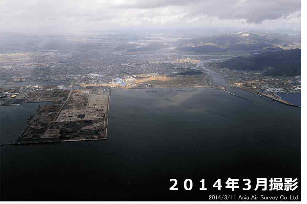
Ishinomaki City
Shinhebita Area, Ishinomaki City
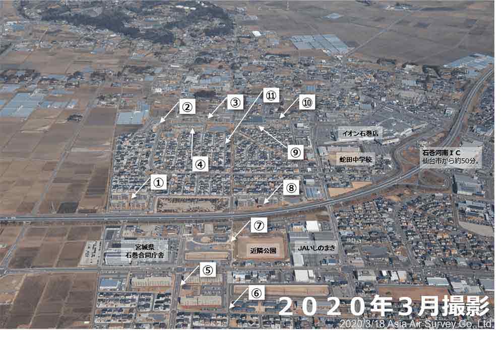
- Reconstruction public housing (Block C)
- Completed in July 2015. 121 houses.
- Reconstruction public housing (Block B)
- Completed in July 2015. 59 houses.
- Reconstruction public housing (Block A)
- Completed 20 houses in March 2015 and 73 houses in March 2016.
- Reconstruction public housing (Block G)
- Completed in March 2015. 80 houses.
- Reconstruction public housing (Block A)
- Completed in January 2016. 207 houses.
- Land readjustment project (Shinhebitaminami District)
- Completed in fiscal 2018. 27.4 ha.
Planned population: 1,990.
Number of planned units: 765 (376 single-family homes, 389 rehabilitated public housing units). - Land readjustment project (Shinhebitaminami District 2)
- Completed in fiscal 2018. 13.7 ha.
- Reconstruction public housing (Block D)
- Completed in March 2016. 80 houses.
- Reconstruction public housing (Block F)
- Completed in March 2015. 59 houses.
- Reconstruction public housing (Block E)
- Completed in March 2015. 43 houses.
- Land readjustment project (Shinhebita District)
- Completed in fiscal 2017. 46.5 ha. Planned population: 3,300.
Number of planned units: 1,265 (730 single-family homes, 535 rehabilitated public housing units).
Winner of the 2016 Townscape Award (Urban Space category) “Special Award.”
Uomachi Area, Minamihama and Shinkadowaki Area, Ishinomaki City
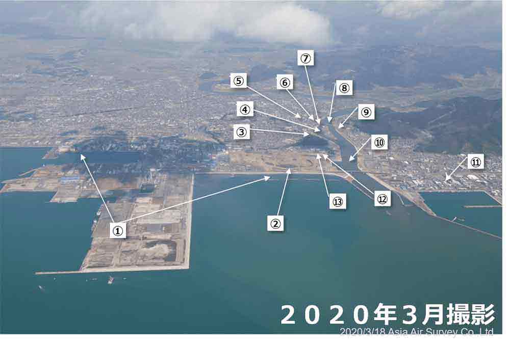
- Seawall (Around Hibarino / Industrial Port)
- To be completed by the end of March 2021.
Height: T.P. 3.5 m and 7.2 m / Length: approx. 17 km (including the length in Higashimatsushima City) - Ishinomaki Minamihama Tsunami Fukkokinen Park
- To be completed by the end of March 2021. Approximately 38.8 ha.
The national government, Miyagi Prefecture, and Ishinomaki City are collaborating to develop facilities commemorating earthquake recovery (ceremonial plaza, etc.) and plazas suitable for civic activities in the heavily damaged Minamihama and Kadowaki areas of the prefecture. - Urban redevelopment (Chuo 1-chome 14-15 districts)
- Completed in fiscal 2016.
- Ishinomaki Genki Ichiba
- Opened in June 2017
Sells fresh seafood, delicious processed seafood products, and local products.
The second-floor eatery overlooks the old Kitakami River. Nearby is a multi-level parking garage. - Tsunami Reconstruction Center Development (Ishinomaki Station Area)
- ・ Disaster Prevention Center Completed in March 2018.
・ The pedestrian deck was completed in April 2019.
・ Nigiwai Koryu Hiroba (Nigiwai Exchange Plaza) was completed in January 2020.
・ Sasaeai Center Completed in March 2020. - Urban Redevelopment (Tachimachi District 2-5)
- Completed in fiscal 2016.
- Urban redevelopment (Chuo District 3-1)
- Completed in fiscal 2015.
- Shin-Utsumi Bridge (tentative name)
- To be completed by the end of March 2021.
- Combined and multipurpose kindergarten/day-care center, etc. (Minato Child Center, Minatoen)
- Completed in March 2015.
- Chinju Bridge (tentative name)
- To be completed by the end of March 2021.
- Fish processing complex
- Recovery of the fish market, fish processing industry and cold storage is underway.
- Land readjustment project (Shinkadowaki District)
- Completed in fiscal 2018.
Planned population: 1,070.
150 reconstruction public housing units and 250 residential lots. - Disaster Remain (Former Kadowaki Elementary School)
- To be completed by the end of March 2021.
To continue to communicate to all the facts and lessons of the earthquake and the desire to recover and rebuild, the bridge will be positioned as an important facility in the Earthquake Disaster Heritage Area, which includes Prayer Park and Mt. Hiyori, and partially preserved.
Ayukawahama Area, Ishiomaki City
- Collective relocation for disaster prevention (Kiyosaki Public Housing) Reconstruction public housing
- Started moving-in from January 2017. 18 houses.
- Oshika Division of the Onagawa Fire Department
- Opened in November 2015.
- Collective relocation for disaster prevention (Ayukawa Kiyosaki)
- Completed in November 2015. 13 houses.
- Oshika sales area of the local wholesale marine products market in Ishinomaki City
- Opened in April 2016.
The market and the refrigerator for ice production were separate buildings before the earthquake and were combined to improve the freshness of live fish - Collective relocation for disaster prevention (Kumano Public Housing) Reconstruction public housing
- Started moving-in in December 2016. 12 houses.
- Collective relocation for disaster prevention (Teraae Public Housing) Reconstruction public housing
- Started moving-in in July 2016. 6 houses.
- Ayukawahama Area (Whale Town Oshika), tourism and product exchange facility (Cottu)
-
"Opened in October 2019.
Gateway to the ship route to Kinkazan, Aji Island, and Tashiro Island.
There is a restaurant, a souvenir store, a shipping company, and an information corner."・Oshika Peninsula Visitors Center
"Opened in October 2019.
An introduction to the natural environment of the region and the lives of the people who live with nature."・Oshika Whale Land
"Completed in March 2020 (Opening TBC).
Introduces the culture of the Oshika Peninsula, which once thrived as a whaling town." - Collective relocation for disaster prevention (Kurosaki)
- Completed in June 2016. 2 houses.
Reconstruction public housing
Started moving-in in December 2017. 9 houses. - Seawall
- To be completed by the end of March 2021.
Height: T.P. 6.0 m / Length: 897.9 m
Higashimatsushima City
Nobiru and Tona Area, Higashimatsushima City
- Seawall (From Tona Coast to Ohigashi Coast)
- Height: T.p. 4.3 m / Length: 3,986 m
- Naruse Mirai Junior High School
- Opened in January 2018. (Naruse No. 1 Junior High School and Naruse No. 2 Junior High School were merged in April 2013)
- Fukko no Mori (Forest of Reconstruction)
- This 10 ha forest behind the Miyanomori Elementary School building was reconstructed by C.W. Nicol with a tree house and viewing platform to create a place to interact with nature.
- Miyanomori Elementary School
- Opened in January 2017.
(The school was established in April 2016 by merging Nobiru Elementary School and Miyato Elementary School) - Okumatsushima Sports Park
- Currently under construction.
Plans include a mallet golf course, gymnasium, tennis courts, baseball field, multi-purpose field, and children's playground. - Disaster prevention experience shelter (KIBOTCHA)
- Opened in July 2018.
A disaster prevention experience shelter where children can play and learn in the renovated former Nobiru Elementary School, which was damaged in the disaster. In addition to serving as a shelter, the facility is equipped with a cafeteria and lodging facilities to promote regional revitalization. - Collective relocation for disaster prevention (Northern Nobiru Hillside Apartments)
- Completed in November 2016. 91.5 ha. 277 houses.
Disaster public housing
Started moving-in in June 2017. 170 houses. - Nobiru Regional Tsunami Disaster Prevention Base Facility (Nobiru Civic Center, Tourism and Products Exchange Center)
-
"Opened in November 2016.
In addition to selling local products, a tourist information area is also provided. - Relocation of the JR Sendai Line
- Operations resumed in May 2015.
Two stations (Nobiru Station and Tona Station) were established in the Nobiru Kitabu Kyuryo complex. - Higashimatsushima City Great East Japan Earthquake Reconstruction Memorial Park
-
・ Earthquake Reconstruction and Legacy Center
Opened in October 2016.
The former Nobiru Station building is used as an exhibition space.・ Remains of the earthquake (Former Nobiru Station platform)
Memories and lessons from the earthquake are passed on to future generations and disaster prevention awareness is promoted.・ Prayer Square
Opened in November 2017.
Established as a place of mourning and rest for souls, it is also a place to pass on the memories and lessons of the earthquake to future generations, and to convey the importance of living in a state of repose." - Seawall (From Omagari Coast to Suzaki Coast)
- Height: T.P. 7.2 m / Length: 9,235 m.
Matsuchima Town
Matsushima Coast Central Square Area, Matsushima Town

- Saigyo Modoshi no Matsu Park Evacuation Area
- Completed in 2015. 2.0 ha.
Panoramic views of Matsushima Bay and Shiogama Bay can be enjoyed from the observation deck, and the on-site ""Roman"" café serves French pastries. - Togetsu Bridge
- Restoration work was completed in 2013.
This bridge spans Oshima Island, from which the name Matsushima is said to be derived. - Sightseeing facility "Matsushima Rikyu, Miyagi Prefecture
- Scheduled to open in the summer of 2020.
- Ishidazawa Disaster Prevention Center Evacuation Area
- Completed in 2017. 2.0 ha.
Serves as a base for disaster prevention during disasters and as a free rest area and base for disaster prevention awareness during normal times. - Sanjukari Evacuation Site
- Completed in 2017. 2.4 ha.
- Matsushima Coastal Park Evacuation Site (Meigetsu-an)
- Completed in 2016.
Kanran-tei, which is related to Date Masamune, is located at this site, and matcha green tea is served. - Seawall
- Height: T.P. 2.1 m / Length: 1,670 m.
- Matsushima Park Disaster Control Green Area
- To be completed by the end of March 2021. 6.0 ha.
Its purpose is to mitigate the effects of tsunamis.
Rifu Town
Hamada Area, Rifu Town
- Evacuation Site 2
- Completed along the Hamada line in February 2017.
170 ㎡. - Evacuation Site 3
- Completed along the Hamada line in February 2017.
220 ㎡. - Town Road Hamada Line
- Opened in February 2017.
Evacuation road Length: 918 m / Width: 6 m. - Seawall
- Completed in March 2020.
Height: T.P. 2.1 m. / Length: 752 m.
Protects adjacent accommodation facilities and restaurants from tsunamis. - Fishing port facility (raised ground and road construction)
- Completed in 2018.
Inside the facility, there is a local oyster store and oyster grill. You can enjoy all-you-can-eat grilled oysters for a set period of time. - Hamada Redevelopment Exchange Center Concept
- As a project for the city, there is an “Ocean Station, Street Station, and Train station” concept. The timeline for the project is TBC.
- Hamada Regional Disaster Management Center (Evacuation Area 1)
- Completed in October 2015. 1,782 ㎡.
Equipped with evacuation facilities and a disaster prevention reserve storehouse.
Shiogama City
Sabusawashima, Shiogama City
- Disaster recovery of fishing port facilities (Sabusawa fishing port slipway)
- Collective relocation for disaster prevention (Sabusawa District)
- Disaster public housing
Completed in October 2015. 11 houses.
A meeting place was also built using board and batten construction.
Much local wood was used and consideration was given to restoring the local forestry and timber industry. - Seawall (Sabusawa (Maehama) District)
- Completed in 2018.
Height: T.P. 4.3 m
Shichigahama Town
Shichigahama Area, Shichigahama Town
- Disaster public housing (Shobutahama District)
- Completed in October 2015. 100 houses.
- Land readjustment project (Shobutahama District)
- Completed in July 2018.
- Seawall (Shobuta-hama)
- Completed in 2018.
Height: T.P. 6.8 m - Shobutahama Seaside Park
- Completed in January 2017.
Adjacent to historic Shobutahama Public Beach, the first swimming beach in Tohoku. The swimming beach reopened in 2016. It is busy year-round with marine sports enthusiasts. - Collective relocation for disaster prevention (Sasayama District)
- Completed in March 2015. 128 lots.
Moved part of Shobutahama District and part of Hanabuchihama District to higher ground. - Land readjustment project (Yogasakihama District B)
- Completed in May 2020.
- Land readjustment project (Yogasakihama District A)
- Completed in March 2018.
- Seawall (Hanabuchi-hama)
- Completed in 2019.
Hight: T.p. 6.8 m - Disaster public housing (Hanabuchihama District)
- Completed in December 2015. 50 houses.
- Ocean Station “Shichinoya.”
- Opened in February 2016.
As a local outlet store for regional produce, it sells fresh seafood at local prices. The restaurant offers beach grills and seafood rice bowls. - 「SHICHI NO RESORT」
- Opened in December 2017.
It has a café and hotel. Marine sports, fishing, barbecue and other activities are also available. Only here you can enjoy a marine resort. - Land readjustment project (Hanabuchihama District)
- Completed in May 2019.
Tagajo City
Sakuragi and Yawata Area, Tagajo City
- Tsunami reconstruction base development (Yawata area) Sanmirai Tagajo / reconstruction complex
-
"Completed in March 2020.
Factories and offices 10.4 ha
Public and social facilities 5.1 ha - Land readjustment project (Miyauchi District)
- Completed in February 2018. 7.1 ha.
Disaster public housing (Miyauchi District)
Completed in December 2016. 50 houses. - Great East Japan Earthquake Monument (Earthquake Legacy Facility)
- Completed in March 2015.
This monument serves three purposes: commemoration, legacy, and commitment to disaster prevention.
Not only citizens, but also visitors from outside the city and future generations who did not experience the earthquake can learn about the disaster and the commitment to disaster prevention in Tagajo City. - Disaster public housing (Sakuragi District)
- Completed in October 2014. 160 houses.
It will also serve as a disaster prevention base for the area, with a disaster prevention storehouse and an evacuation space on the roof. - Disaster public housing (Tsurugaya District)
- Completed in March 2016. 274 houses.
Sendai City
Sendai Port, Sendai City
- Sendai Shiogama Port (Sendai Port area)
- The volume of cargo handled in 2018 was 42.28 million tons
(1.27 times more than in 2010).
Main goods: finished car products, ferry cargo, crude oil, heavy oil, pulp - New seawall (Sendai Port area)
- To be completed by the end of March 2021.
Height: T.P. 4.0 m, 7.2 m / Length: 9.2 km.
Fences, etc. are installed along the surrounding shoreline roads to prevent flotsam from entering residential areas, etc. - Gamo tidal flat (nature restoration area)
- A variety of migratory birds roost here at all times of the year. It is a breeding area for the
endangered little tern and a valuable wintering area for brent geese, the national designated
natural monument.
The lowest mountain in Japan (Mt. Hiyori: 3 m) is also nearby. - Land readjustment project (Northern Gamo District)
- Scheduled to be completed in March 2022. 92.1 ha.
After the collective relocation for disaster prevention, the site was consolidated and urban infrastructure was redeveloped.
Logistics warehouses and other facilities are being built here. - Sendai City Umi no Mori Aquarium
- Opened in July 2015.
The number of visitors to the aquarium has exceeded 5 million in 4 years.
The large aquarium, with a water volume of about 1,000 tons, replicates the sea of the Sanriku Coast and displays 25,000 creatures from 50 species.
Dolphin, sea lion and bird shows are also popular. - Sendai Port Ferry Terminal
- This is the departure and arrival point of Japan's longest regular ferry service between
Tomakomai, Sendai and Nagoya.
There are many attractions on the ferry. - Yume Messe Miyagi (Miyagi Industrial Exchange Center)
- Contributes to the promotion of prefectural industries and the enhancement of culture in the prefecture by hosting and supporting exhibitions and business meetings.
Arai Area, Sendai City
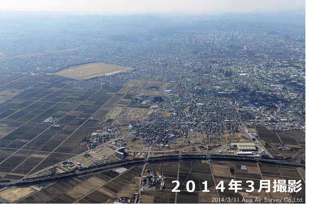
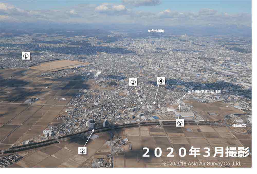
- Eastern Sendai Area
- Salt removal work, farmland restoration, and facility restoration were carried out, and all
farmland was restored to cultivation in fiscal 2015.
Large area construction (1,900 ha) was completed in March 2019.
Land readjustment is scheduled to be completed in March 2021.
In the surrounding area, there are a number of forests known as “Igune,” and the landscape floating in the water field area is a true “green floating island.” - Collective relocation for disaster prevention (Arai Higashi District)
- Completed in fiscal 2014. 136 lots
(52 of which are lots for private residences)."Reconstruction public housing
Completed 197 houses in February 2014,
15 houses in November 2014 and 101 houses in May 2015. - Land readjustment project (Arai District)
- Completed in March 2018. Approximately 149.9 ha.
With the opening of the Tozai Line of the Sendai City Subway, the area around Arai Station, the starting point of the line, was developed and a new city was born.
It also functions as a place for collective relocation for disaster prevention. The residential population has doubled (11,000 people). - Sendai Gigs
- Opened in May 2018.
A multi-purpose live hall with a capacity of 1,500 people.
It is expected to become a new cultural center for the eastern part of Sendai. - Sendai 3/11 Memorial Community Center
- Opened in February 2016.
An exhibition and communication space that conveys the damage caused by the earthquake and the status of recovery and reconstruction.
Admission is free.
Area around the mouth of Natori River, Sendai City and Naroti City
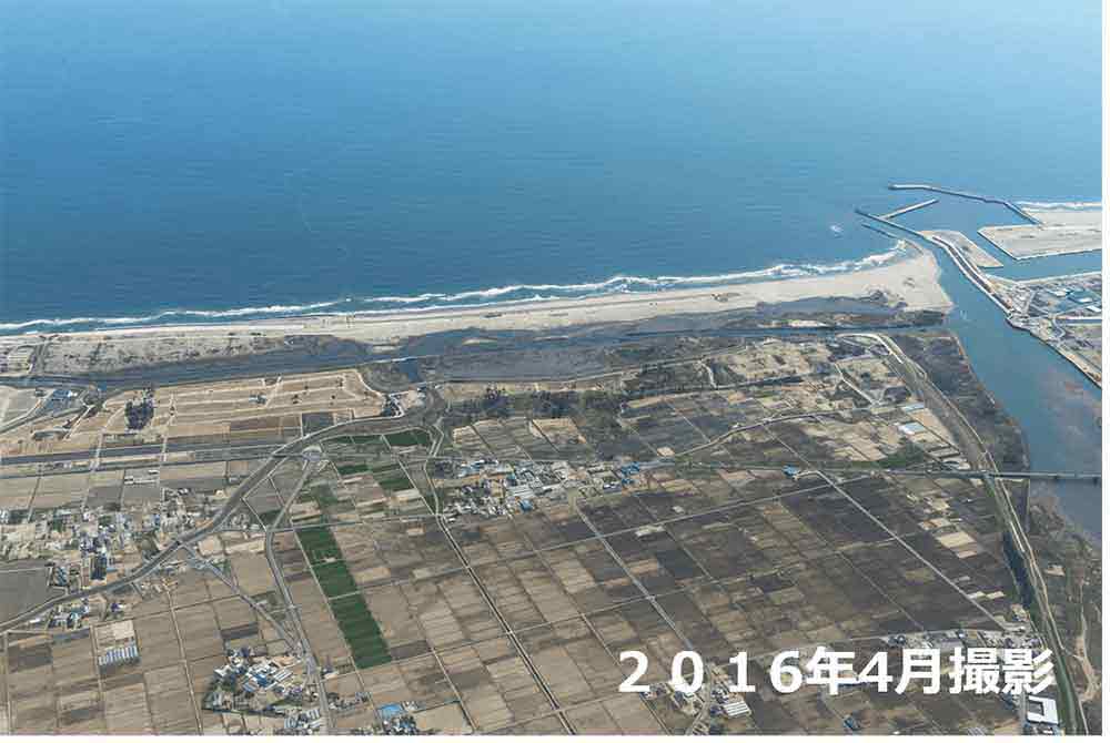
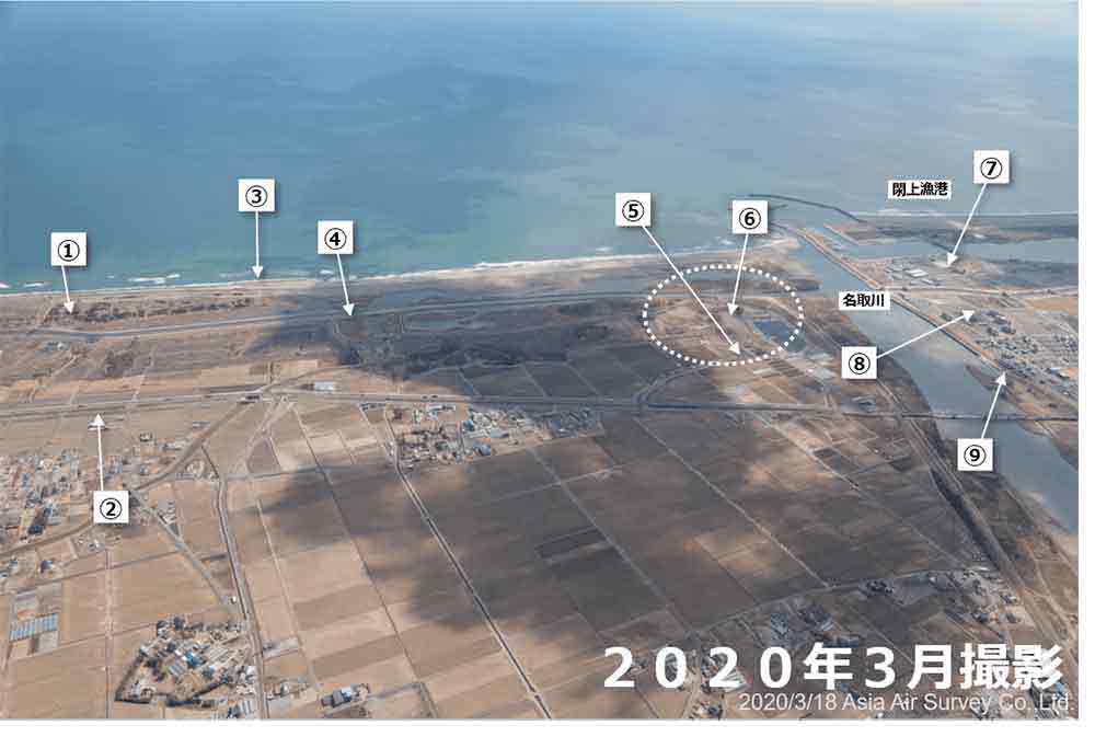
- Coastal disaster prevention forests
- To be completed by the end of March 2021.
Restoration of the natural environment and coastal landscape.
Also referred to as the Michinoku Shiokaze Trail, which runs from the city of Hachinohe in Aomori Prefecture to the city of Soma in Fukushima Prefecture. - Raised road
- (Eastern Reconstruction Road, etc.)
The entire road opened in November 2019.
Embankment height: 6 m / Length: 10.2 km.
It is the key to several defense measures to mitigate tsunami damage following the coastal levee and coastal protection forest. - Coastal levee (south coast of Sendai)
- Completed in March 2017.
Height: T.P. 7.2 m / Length: approx. 29 km (including 4 km of Natori Coast) - Teizan Canal
- Length: 28.9 km from the mouth of the Abukuma River to Matsushima Bay. The canal was opened by order of Date Masamune and maintained for about 300 years, and was used by boats loaded with tribute rice and timber.
- Aqua Ignis Sendai (food, agriculture and spa facilities)
- Scheduled to be completed in October 2021.
The site has an area of 34,000 ㎡ and a total floorspace of 10,300 ㎡.
It is a combined food and agriculture resort complex with a spa facility, a farm restaurant using local ingredients and overseen by a renowned chef, a bakery, a bazaar and a sales building. - Use of a collective relocation remains (Fujitsuka District, Sendai)
- Total area 11.3 ha.
The site is a combination of three uses: an zone for public use (*), an zone for commercial use, and an area for a solar power project.
* It will be a place to experience and learn about nature by preserving the Idoura tidal flat environment and utilizing the adjacent coastal park.
To be completed by the end of March 2021. - Yuriage Fish Processing Complex
- 4.7 ha. The site of the fish processing industry is constantly developing.
- Land readjustment project (Yuriage District, Natori City)
- Completed in March 2020. 56.8 ha. Raised by 3 to 4 meters.
The opening of the city took place in May 2019.
There are several tourism and recreation facilities, including an earthquake memorial park, a fisharina, a cycling center, and a spa.
It is located near the Natori IC and Sendai Airport."Michino Shiokaze Trail Natori Trail Center
Provides information about the entire trail as well as meeting rooms and lounges for hikers, residents and visitors to relax and interact. - Kawamachi Terrace Yuriage
- Opened in April 2019.
A redeveloped commercial street built along the Natori River Dam.
There is also a food court with a variety of local foods.
Iwanuma City
Tamauranishi Area, Iwanuma City
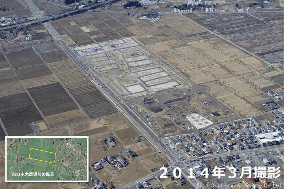
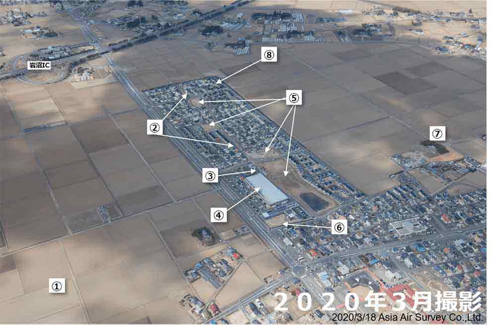
- Overview of Tamauranishi Area
- Six coastal areas have been relocated.
Housing Site Development: August 2012 - April 2014
Total construction cost: 19.6 billion yen (including other adjacent areas)
Construction area: 19.96 ha Building lots: 158
Awarded the Ishikawa Prize by the City Planning Institute of Japan in 2016 and the Outstanding Urban Planning Award by the Japan Society of Urban and Regional Planners in 2015. - Teizan Green Path
- A pedestrian-only path connecting four parks and running east-west through the district.
- A drinking water tank
- Stocked for emergency use.
Designed by a student at the local junior high school. - Shopping mall
- Opened in July 2015.
This supermarket features a produce area selling local products and seafood, as well as a ""Fureai Terrace"" for dining on local ingredients. - Park
- Four parks have been developed, each with its own theme.
- Higashi Day-care Center
- A kindergarten that was damaged by the tsunami was rebuilt and a childcare center was added.
- Meeting places
- There are 3 meeting places in the park.
- Disaster public housing
- Completed in March 2015. 178 houses.
There are 3 sites in the district.
Watari Town
Arahama Area, Watari Town
- Disaster public housing (Arahama Nishikigura District)
- Completed in August 2014. 100 houses.
- Collective relocation for disaster prevention (Arahama Nakano District)
- Completed in May 2015. 32 houses.
Disaster public housing
Completed in October 2014. 28 houses. - Kizuna Port Watari
- Completed in October 2014.
Local seafood and produce are sold at the Torinoumi Fureai Market on the 1st floor.
Strawberries are especially popular."Strawberry Complex
In an effort to revive the best strawberry production in the Tohoku region, large-scale facilities have been built at three locations in the city. - Seawall
- Height: T.P. 3.6 m.
- Watari Onsen Torinoumi
- The day-trip bath reopened in October 2014. It also serves seasonal dishes such as “Harako-Meshi.”
- Arahama Nigiwai Corridor Shopping Street
- Opened in March 2015.
A collection of stores damaged by the disaster. Restaurants, seafood stores, surf stores, etc. - Torinoumi Park
- Opened in April 2018.
There is an athletics field, soccer field, baseball field, and an evacuation hill 9 meters above sea level.
Also used as a venue for summer festivals. - Multi-purpose Plaza
- Completed in March 2020.
- Seawall
- Height: T.P. 7.2 m.
Yamamoto Town
Shinyamashita Station Area, Yamamoto Town
- Yamamoto Town Hall
- Opened in May 2019.
The government building damaged by the earthquake was demolished.
A prefabricated office building was used temporarily, and then a new building was constructed and restored as a ""symbol of reconstruction"" and the full completion of hardware development. - Reconstruction public housing (Tsubame no Mori District)
- Completed in March 2016. 346 houses.
The first phase of 50 houses (completed June 2013) was the first project to be delivered in the prefecture. - Evacuation road construction
- Yamamoto Town child care facility
- Opened in July 2016.
Consists of Tsubaki no Mori kindergarten and a children's center. - Yamashita 2 Elementary School
- Opened in August 2016.
This school was damaged by the tsunami and has been relocated and repaired. - Development of a tsunami disaster management base / collective relocation for disaster prevention (Tsubame no Mori District)
- 37.4 ha
The ""opening of the city"" took place in October 2016.
Compact urban development based on the New Yamashita Station and National Highway 6. - New Yamashita Station
- About 12 lm of the JR Joban line, which was out of service in the city, was moved inland and
elevated.
New Yamashita Station was also moved 1.1 km inland and restored, and resumed service in December 2016.
It takes about 45 minutes to travel from Sendai Station. - Yamamoto Town Disaster Prevention Center and Yamashita Community Exchange Center
- “Tsubame-no-mori Hidamari Hall” Opened in October 2017.
- Strawberry Complex
- Growing facilities were built to restore the town to one of the major strawberry growing areas in
the Tohoku region.
In November 2014, all 52 participating farms in areas 1 to 4 began delivering strawberries. - Yamamoto Sunflower Festival
- (Held from July to August in the Shinhama and Kasano areas).
It was a spectacular sight to see about 2.5 million sunflowers in full bloom on a large area of farmland that had recovered from the earthquake and had been made into a large field.
Fukushima Prefecture
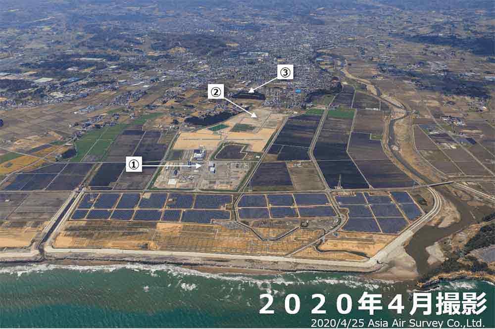
Shinchi Town
Around Shinchi Station, Shinchi Town

- Tsurushi Disaster Prevention Green Park
- Opened in December, 2019. Located in the area damaged by tsunami (the original site of collective relocation for disaster prevention). It has a caravan site for camping, playground equipment and so on in the area of approx. 18 ha. Beside Tsurishi Beach.
- Shinchi Station Square Futsal Ground
- "Smile Dome" Completed in March, 2019. Constructed on a site of 5,460 square meters on the east side of the station. It has approximately 2,000-spare-meter coart which can accommodate two futsal fiels.
- Shinchi Station square multi-purpose commercial facility "Kankai Plaza
- Opened in April, 2019. The facility is located in the southwest area of the station. The store is a one-story building with a floor area of 500 square meters.
- JR Shinchi Station
- The old station building collapsed in the tsunami of the Great East Japan Earthquake, remaining a part of the platform and the bridge over the railways. The newly constructed station building is 300 m inlying from where the old one was.
- Shinchi Town Cultural Exchange Center "Kankai Hall
- Completed in January, 2020.
The facility consists of multi-purpose hall with a maximum of 445 seats, music studio and conference room. - Hotel Grado and Tsurushinoyu
- In June 2019, an accommodation and spa facility connected to the hotel were opened as part of a reconstruction project around JR Shinchi Station in Shinchi Town, which was damaged by the Great East Japan Earthquake and tsunami. The four-story steel-framed hotel (108 rooms) and the single-story steel-framed spa facility have a total area of approximately 4,550 square meters.
- Shinchi Town Energy Center
- Completed in November 2018. The facility will provide heat and power to the facilities around Shinchi station using liquefied natural gas (LNG) transported from the port of Soma. The efficient use of energy will be managed through local production for local consumption.
- Tsurushi Beach
- It will reopen in July 2019, nine years after the Great East Japan Earthquake. A beach known for being shallow and large, located in the northernmost part of Fukushima Prefecture. The waves are gentle, making it popular with families with young children."
Soma City
Matsukawa Osu coast, Soma City
- Coastal disaster prevention forests
- Much of the former coastal protection forest was lost in the Great East Japan Earthquake.
After the earthquake, restoration work began in fiscal 2011.
In addition to protecting residential areas and farmland from wind and tidal damage and preserving the living environment, the project also aims to restore coastal protection forests in consideration of reducing the impact of tsunamis. - Municipal Osu Matsukawa Line
- The city road, located between the Pacific Ocean and Matsukawaura, was crippled by a tsunami over 9
meters high that washed away the entire levee. In April 2018, a 5.9-kilometer section of the road was
reopened to traffic.
The road is an integral part of the coastal levee, which was raised by about one meter from its pre-earthquake level, making it a resilient structure that will not immediately collapse even if a tsunami inundates the levee. - Matsukawaura
- This brackish lake with a mix of seawater and freshwater, separated from the Pacific Ocean by a sandbar, is about 7 km long from north to south, 1.5 km wide, 5.5 m deep, and covers an area of 738 hectares. It is one of the 100 Landscapes of Japan and offers beautiful scenery. There used to be a large amount of green laver in the bay, but they were all washed away by the tsunami of the Great East Japan Earthquake. After the earthquake, seawalls and other facilities were restored, radiation monitoring of the accident at TEPCO's Fukushima Daiichi nuclear power plant continued, and in February 2018, green laver was shipped for the first time in about seven years.
- Matsukawaura-ohashi Bridge
- The site was developed in 1991 as part of the renovation of the Matsukawaura fishing port.
It is a sea bridge (520.3 m long) over the mouth of the Matsukawaura River formed by the sand spit. The Soma City Road Osu-Matsugawa Line connects the Haragama area on the mainland side with the Unomisaki area on the spit side, and also serves as a shortcut to the Isobe area on the south side of Matsukawaura. - Tsunami and Earthquake Victims Memorial Hall of Soma City
- Opened in April 2015.
The purpose of this facility is to commemorate the victims of the earthquake, provide a place of
comfort for grieving families, pass on the sights of the Ohama, Haragama, and Isobe areas damaged by
the Great East Japan Earthquake and tsunami to future generations, and provide a place for visitors to
interact with each other.
Exhibits include photographs of scenes before the earthquake and local events, as well as video footage from the day of the earthquake. - Haragama cargo-sorting facility (Soma Haragama Regional Wholesale Market)
- Completed in September 2016. It has three floors above ground and a total area of about 8,432 square meters. There is an exhibition hall for visitors, an observation deck (for events), a kitchen and other facilities. Visitors can also view ceri and radiation testing. The exterior of the building features Japanese elements, such as a sloping roof and namako walls, which recall the history and tradition of Soma.
Minamisoma City
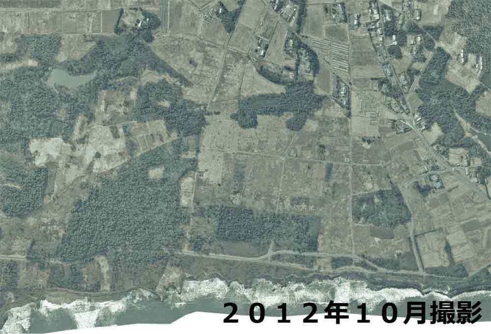
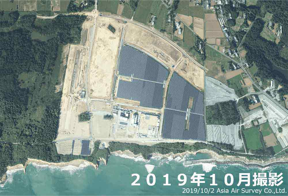
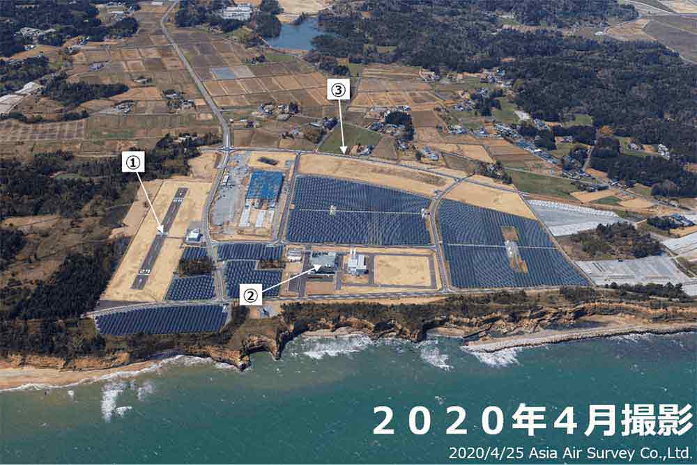
Fukushima Robot Test Field, Minamisoma City
- Fukushima Robot Test Field
- The facility is located in a newly developed industrial park in the city of Minamisoma. The center will be able to conduct research and development, demonstration testing, performance evaluation and pilot training while replicating the actual operating environment of unmanned aerial vehicles, disaster response robots, self-propelled robots, underwater exploration robots and other robots in the land, sea and air domains that will be used for logistics, infrastructure inspection and major disasters. It is the first major research and development center of its kind in the world. The center will gradually open starting in fiscal 2018 and be fully operational by March 2020.
- Recovery industrial park
- An industrial park was constructed in Shibusa/Kaibama area of approx. 70 ha. It has a robot research center "Fukushima Robot Test Field.
- Coastal Area Agricultural Revitalization Research Center
- Completed in March 2016. This new research center has opened in the Haramachiku Kaibama area to revive agriculture in evacuated areas that were severely damaged by the nuclear disaster.
Around Odaka Station, Minamisoma City
- Odaka Industrial Technology and Commerce High shool
- Established in April 2017 through the merger of Fukushimaken Tachiodakashogyo High School and Odaka Industrial Technology and Commerce High School. It is the first school in Fukushima Prefecture to be designated as a Super Professional High School (SPH) by the Ministry of Education, Culture, Sports, Science and Technology.
- [Odaka Junior High School]
- After the Great East Japan Earthquake and nuclear accident, classes were held in a temporary school building in Kashima Ward, but resumed in the original building in April 2017.
- [Four elementary schools in Odaka District]
- After the evacuation order was lifted, four elementary schools in Odaka Ward (Odaka Elementary School, Fukuura Elementary School, Kanefusa Elementary School and Hatohara Elementary School) held joint classes in the Odaka Elementary School building.
- Odaka Station
- Operations were suspended after the Great East Japan Earthquake and nuclear power plant accident, but resumed in July 2016. The Joban Line will fully reopen in March 2020.
- [Daiyu8]
- Opened in June, 2019.
- [Odaka Ward Office / Odaka Exchange Center]
- In January 2019, the "Odaka Exchange Center," a remodeled base facility in Odaka Ward, opened across from the Odaka Ward office. The approximately 5,800 ㎡ space will include a children's playground (indoor), a turf field, a daycare center, a coworking space, and a retail and food service area.
Namie Town
Fukushima Hydrogen Energy Research Field, Namie Town
- Fukushima Robot Test Field (Namie Runway)
- Completed in March 2020. As a runway for unmanned aircraft, the facility will be used for flight testing and pilot training. The runway at Minamisoma is aligned north-south, while the runway at Namie is aligned east-west, allowing aircraft to fly out to sea immediately after take-off.
- Fukushima Hydrogen Energy Research Field (FH2R)
- Completed in March 2020. A hydrogen production facility with one of the largest hydrogen production units in the world, powered by renewable energy. At the Tokyo Olympic and Paralympic Games, hydrogen produced at this facility will be used in the Olympic cauldron and the torch relay.
- Industrial park (Tanashio District)
- To be completed in March, 2020. 10 parcels, 49 ha. Projects and companies related to Fukushima Innovation Coast Framework will be invited.
Around Namie Station, Namie Town
- AEON Namie Store
- Opened in July 2019. The city's only supermarket sells fresh food and daily necessities. Fresh fish landed at the Ukedo fishing port is also sold here.
- Namie Town Hall
- Roadside Station Namie
- One part scheduled to open in the summer of 2020. There is also a sake production tour and sales facility, as well as an Obori Soma-yaki pottery experience and sales facility. It also provides information on the current status of tourism and redevelopment in the area.
- Namie Station
- Namie Town Community Sports Center
- The main arena, sub arena, meeting rooms and training rooms are used as venues for health promotion activities and lifelong learning opportunities.
Ukedo Fishery Port, Namie Town
- Seawall (Coast around Ukedo Fishery Port)
- To be completed by the end of March 2021. Height: 7.2m / Length: 1.1 km
- Namie Town fish processing complex
- The fish processing facility will begin operations in April 2020. The plan is to produce and sell processed marine products such as whitebait and other fish landed at the Ukedo fishing port.
- Ukedo Fishery Port (Ukedo Regional Wholesale Market)
- Auctions resumed in April 2020. Currently, fishing is limited to two to three days per week, and the fresh fish landed is mainly shipped to Toyosu and other markets. The fish is also sold in seven Aeon stores in the prefecture.
Futaba Town
Nakano area, Futaba Town
- Rebuilding the industrial base (work base) in the Nakano area.
- In order to facilitate the resumption of business in the city and the entry of companies in Futaba, an industrial park of about 50 hectares has been created. In December 2019, the first company, "Futaba Chuo Ascon," started operations.
- Futaba Business Incubation and Community Center
- As the centerpiece of the Nakano Ward Reconstruction Industrial Base, the facility is located next to the Great East Japan Earthquake and Nuclear Disaster Memorial Museum and Reconstruction Memorial Park and consists of restaurants and rental offices. Construction is currently underway for the opening ceremony.
- Fukushima 3.11 Memorial Park
- In addition to providing mourning and peace for the souls of the victims, the facility is intended to convey the strong will to rebuild to the people of Japan and overseas. The park, adjacent to the Great East Japan Earthquake and Nuclear Disaster Memorial Museum, will serve as the centerpiece of reconstruction tourism. Construction is currently underway for the opening ceremony.
- The Great East Japan Earthquake and Nuclear Disaster Memorial Museum
- A place of learning where the records and lessons of the earthquake and nuclear accident will be shared with people in Japan and abroad, and where reconstruction efforts will be communicated. Construction is currently underway for the opening ceremony.
- Seawall (Coast around Futaba Nakahama District)
- Completed in 2019.
Hight: TP + 7.2 m / Length: 733.9 km
Around Futaba Station, Futaba town
- JR Futaba Station
- The JR Joban Line will be fully opened on March 14, 2020. Futaba Station will be reborn as a new station building, and a free passageway will be built so that passengers can travel between the east and west sides of the station. With three round trip limited express trains (between Shinagawa and Sendai) and 11 round trip normal trains (between Iwaki and Haranomachi), the station is convenient for commuters to and from Nakano Ward and for reconstruction tourism.
- Development of a residential base in the area west of the station.
- A new urban development is being implemented for Futaba City on the west side of Futaba Station, which is a new starting point. As new opportunities are sought for the city, the return, residence, and participation of a diverse population will be encouraged with the goal of creating a city that goes beyond redevelopment and becomes a model for regional development. The goal is to begin housing in the city around spring 2022.
Okuma Town
Ogawara specific center for reconstruction and revitalization, Okuma Town
- Group home for elderly with dementia (Ookuma Mominokikai).
- Welfare association office Welfare center for residents Welfare facilities are being developed to create an environment where people can continue to live in the city with peace of mind. Opened in April 2020.
- Disaster public housing (District 2)
- Completed in April, 2020. 42 houses. Detached house.
- Disaster public housing (District 1)
- Completed in May, 2019. 50 houses.
Detached house.
Fukushima reconstruction rental housing
Completed in September, 2019. 40 houses.
Two-story apartment house. - Okuma Town Hall
- Completed in March 2019. The opening ceremony was held in April of the same year, and operations began in May. The building is roughly divided into Building A (Government Building) and Building B (Emergency Protection Building).
- Dining Ogawara (restaurant)
- Opened in March 2020. Opening hours are 11:45 a.m. to 1:30 p.m. and 5:00 p.m. to 11:00 p.m. (closed on weekends and holidays). It is the only restaurant in the city that is open at night. It serves Japanese food and sake and other drinks made with ingredients from the prefecture.
- Okuma Shokudo (restaurant)
- In September 2016, TEPCO set up a single dormitory with a cafeteria. It was opened to the public in April 2017. It is open to the public from 11:30 a.m. to 2:00 p.m. on weekdays. Daily special meals, curries and noodles are served daily.
Tomioka Town
Around Tomioka station, Tomioka Town
- Tomioka Station
- ・ Tomioka Station reopened in October 2017 (operations resumed south of Tomioka Station).
・ In March 2020, operations resumed north of Tomioka Station on the Joban Line (between Tomioka and Namie Stations).
・ Sakura Station KINONE (convenience store) was added. - Sakura Mall Tomioka (Multi-purpose commercial facility)
- Fully opened in March 2017. Supermarkets, hardware stores and other stores are concentrated in the area, providing the necessities of daily life. The food court sells "Hamadori Ramen," which won a silver medal at the 2019 JR East Souvenir Grand Prix.
- TEPCO Decommissioning Archive Center
- ・Opened in November 2018.
・ Passing on the memory and record of the nuclear accident. The current status of the decommissioning project is presented. - Tomioka Town Hall
- The main office building of the city government was reopened in March 2017.
The attached cultural exchange centre ""Forest of Learning"" is equipped with a library and a large auditorium with 500 seats.
・ The symbol of the city is cherry blossom (the rows of cherry trees in the forest at night are famous).
Naraha Town
Around Emifuru Town Naraha, Naraha Town
- Salmon fishing dam
- The salmon fishing dam was reopened in 2015. Before the earthquake, the town was one of the largest salmon producers in Japan, and many tourists visited the town during the season when salmon came upstream. The Kido River Fishermen's Cooperative Association operates a direct sales store nearby where you can enjoy the flavors of autumn.
- Naraha Sky Arena
- It was built with a grant to accelerate the rebuilding of Fukushima and opened in April 2019. A new sports and cultural exchange facility that connects friends, families and generations through sports, while watching over the healthy development of children and supporting a "healthy and attractive life for all."
- Naraha Town Hall
- After the earthquake, the center was relocated to Aizumisato City and Iwaki (with the establishment of the Aizumisato, Iwaki, and Iwaki Yagawasen branches), but resumed operations in June 2014.
- Emifuru Town Naraha
- To promote the revitalization of residents' lifestyles and local businesses, as well as to create
new housing, the area has formed a vibrant base with a concentration of residential, commercial,
medical, social and exchange facilities.
Kokonara Shopping Street (In Emifuru Town)
Local businesses (supermarkets, bakeries, dry cleaners, etc.), a large company (Home Center) that was established in the town before the earthquake, and businesses from neighboring Iwaki City and Tomioka Town were invited to participate in a public-private partnership model in June 2018.Exchange Center Naraha CANvas (In Emifuru Town)
It was designed in a workshop to fulfil the desire of citizens to create a facility that truly symbolizes the reconstruction of the city: "an exchange center for all." It opened in July 2018 with a multipurpose hall for meetings, a band room, a children's room and a work space.
Around J Village, Naraha Town
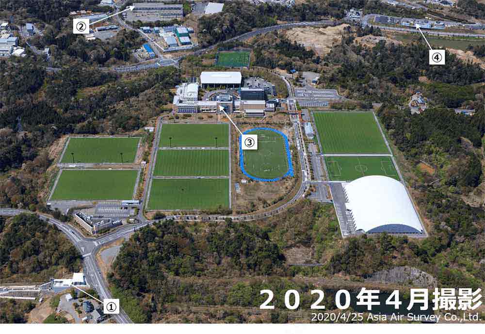
- J village station
- It opened in April 2019 as a temporary station for events. It will become permanent in March 2020.
- Naraha Town Minami Industrial Park
- An industrial park where several businesses operated before the earthquake. Since the earthquake, companies such as Toyotsu Lithium, Keiwa Industries and Beltecno Plant Industries have located in the area.
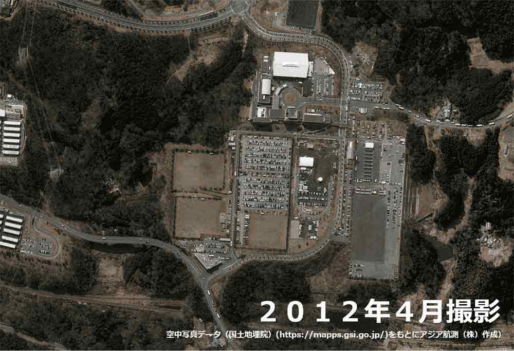
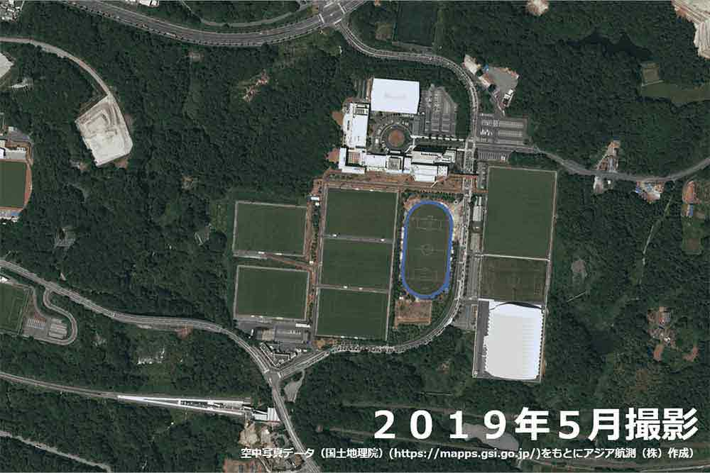
- J village
- It fully reopened in April 2019. The 49-hectare facility, about the size of Tokyo Dome, has eight natural grass fields, including a stadium with spectator seating, two artificial turf fields, an all-weather soccer training field, a rainy-day training field, a 200-room hotel, a gymnasium, an arena and a swimming pool. Immediately after the earthquake, it became the base for the response to the accident at TEPCO's Fukushima Daiichi nuclear power plant.
- Roadside Station Naraha
- Partially reopened in April 2019. A "hot spring recreation facility" that uses hot spring water from the surrounding area, a "product hall" that offers local specialties (reopened in June 2020), and a "street rest area" that offers rest and toilet functions, street information, and local information.
Hirono Town
Around Hirono Station, Hirono Town
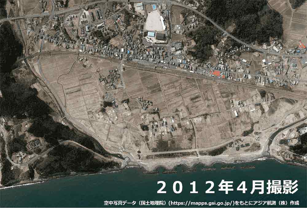
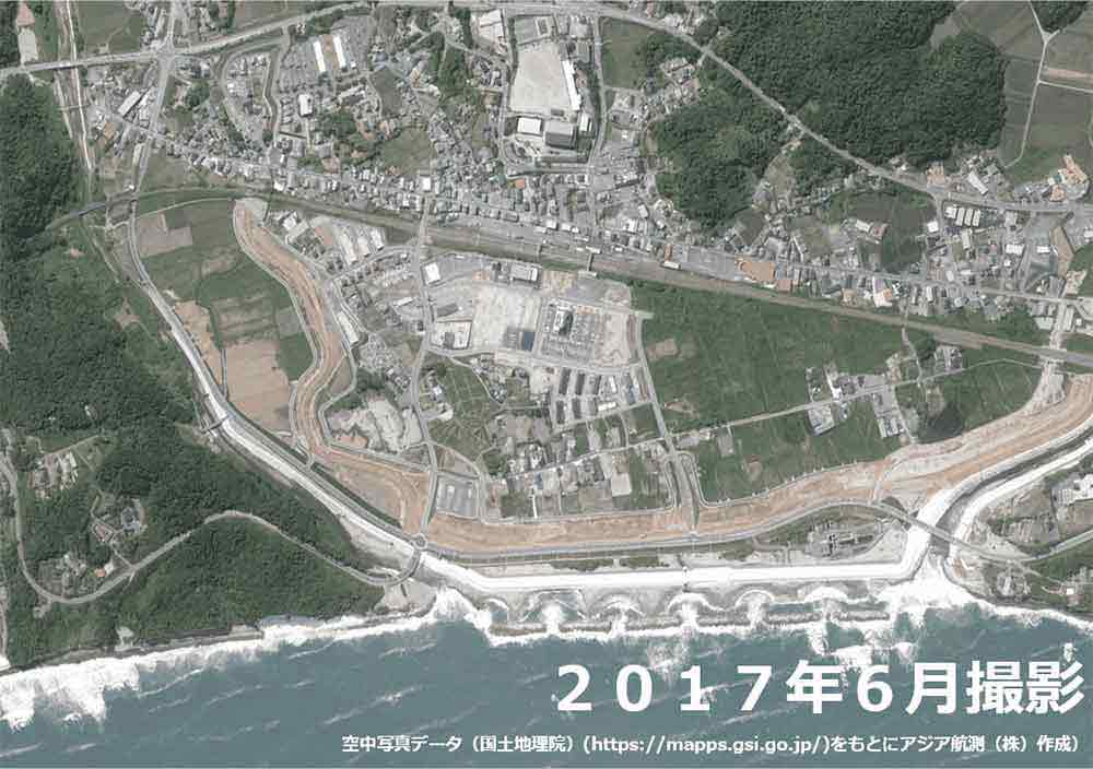
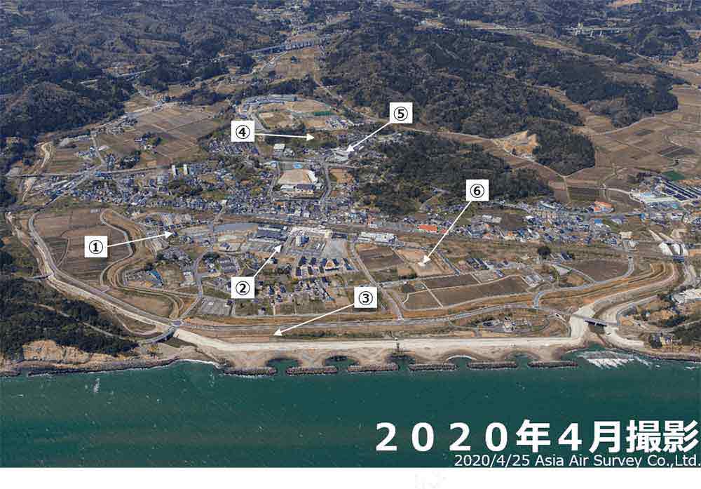
- Disaster public housing
- (Hironohara Housing Complex) Completed in September, 2014. 48 houses.
- Hirono Station east-side development project (District 1)
- April 2016 Opening of ""Hirono Mirai Office,"" a six-story office building
April 2017 Opening of the ""Bridge of the Future,"" a railroad bridge connecting the east and west
sides of Hirono Station
September 2017 Completion of ""Roigent Park Hirono,"" a 114-unit residential development March 2018 Completion of the ""Hirono Station East Exit Plaza,"" the entrance to the east side of Hirono Station
October 2018 Opening of business hotel (222 rooms) ""Hatago Inn Fukushima Hirono.” - Hirono Disaster Prevention Park
- Opened in August 2016. Placed with a levee to strengthen the disaster response capacity of the tsunami damaged area of Hirono Station East. Over 500 volunteers from all over Japan participated in planting Japanese black pine and Quercus seedlings.
- Mikan no Oka (Tangerine Hill)
- A field of citrus trees planted on a hill overlooking the sea symbolizes Hirono's mantra: "The city that brings spring to Tohoku." When winter comes, the oranges bear orange fruit and make a vibrant sight. In addition to oranges, the town's specialties include local bananas grown in Futatsunuma General Park (the bananas come from a town with a hill of oranges, whose beautiful horizon glistens in the morning sun).
- Public commercial facility "Hirono Terrace
- Opened in March, 2016. Five stores and restaurants including supermarket AEON Hirono Store are open.
- Hirono Station east-side development project
- (District 2)
Housing complex (56 parcels) is under construction.
Around Futaba Future School, Hirono Town
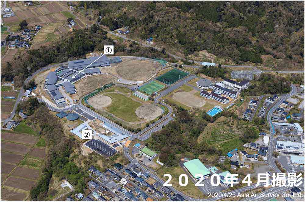
- Prefectural Futaba Future School
- A comprehensive middle and high school in the prefecture. High School: opened in April 2015, Middle
School: opened in April 2019.
Selected as an SGH (2015-2019) and a project (glocal type) to promote education reform at high schools in partnership with the local community (from 2020).
A student-run ""café Fuu"" operates in the community space in the school building. - Hirono Kids Park (Hiro Park)
- Opened on April 6, 2019.
The school is an accredited childcare facility.
Iwaki City
Around Hisanohama Station, Iwaki City
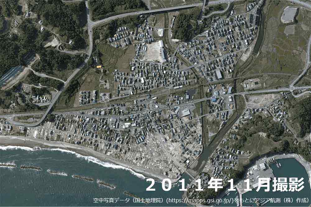
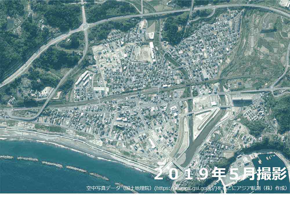
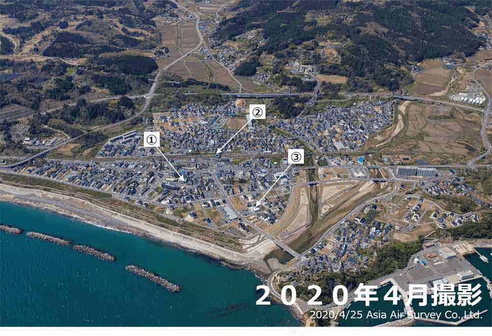
- Iwaki City Community Disaster Prevention Exchange Center Kunihama Okubo Rikan.
- This center was established as an emergency evacuation facility for residents in areas that could be inundated by a tsunami. The functions of the Hisanohama and Okubo branches and the Hisanohama Community Center were consolidated and merged.
- Hisanohama Station (JR Joban line)
- The facility was closed due to the Great East Japan Earthquake on March 11, 2011, but reopened on May 14, 2011.
- Hisanohama Station (JR Joban line)
- Area: 28.4 ha, Number of parcels:213
Construction period: FY 2012 to FY 2018
Usuiso area, Iwaki City
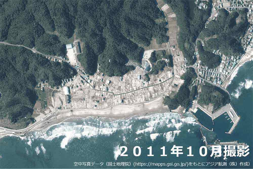
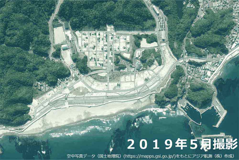
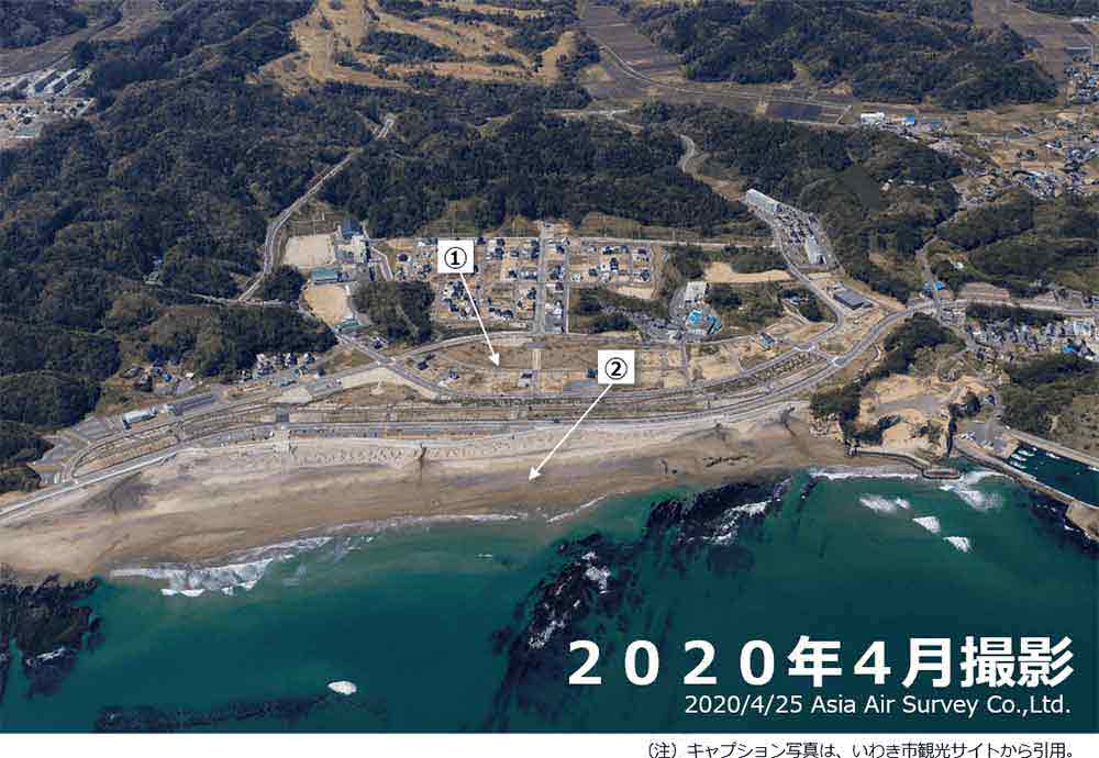
- Usuiso land readjustment project for earthquake recovery
- 37.0 ha, 185 parcels. Construction period: FY 2012 to FY 2017
- Usuiso Beach
- The beach was severely damaged by the Great East Japan Earthquake of March 11, 2011, but was
reopened in the summer of 2017 after the construction of a seawall and maintenance of the
shoreline.
The beautiful sandy beach and crystal clear water were voted one of the 100 best beaches in Japan.
There is also a parking lot, restrooms, showers and a park.
Toyoma area, Iwaki City
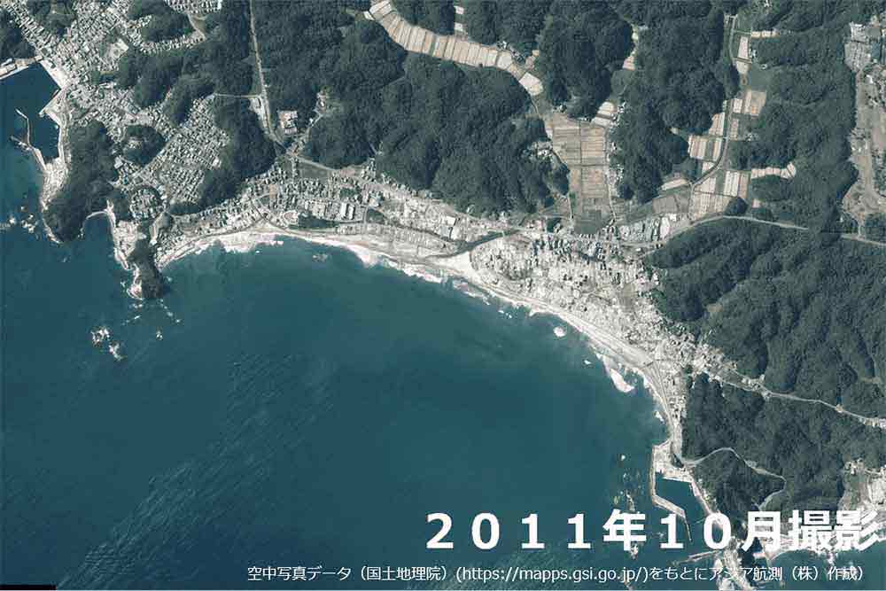
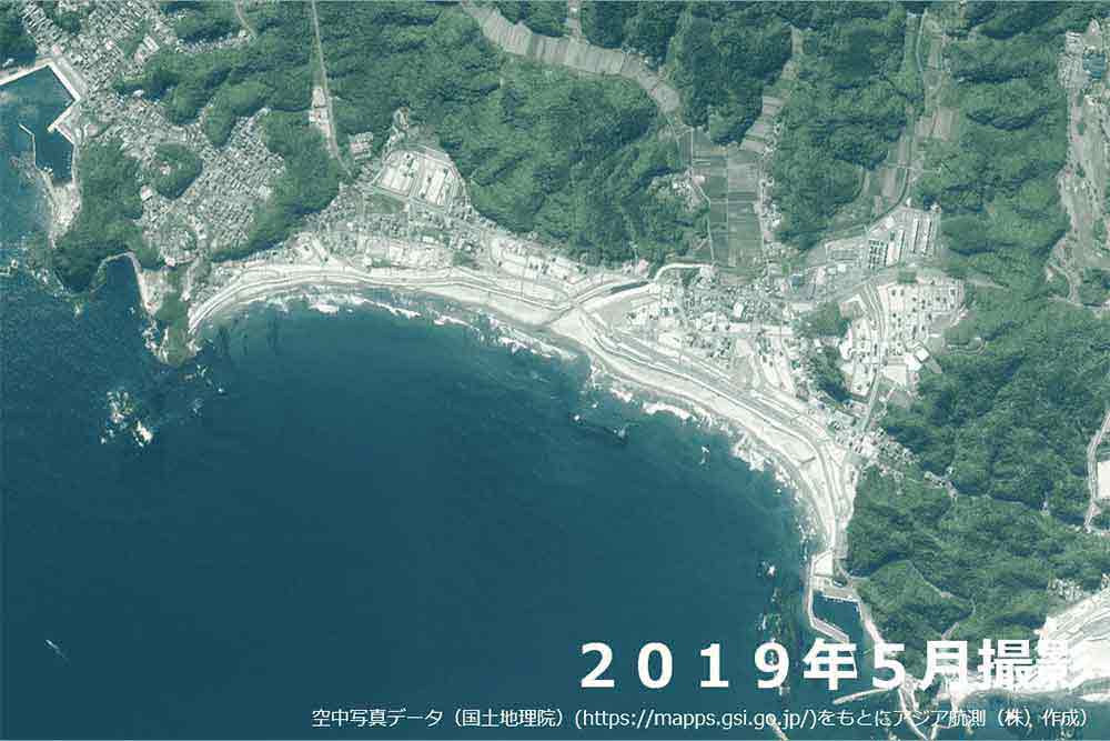
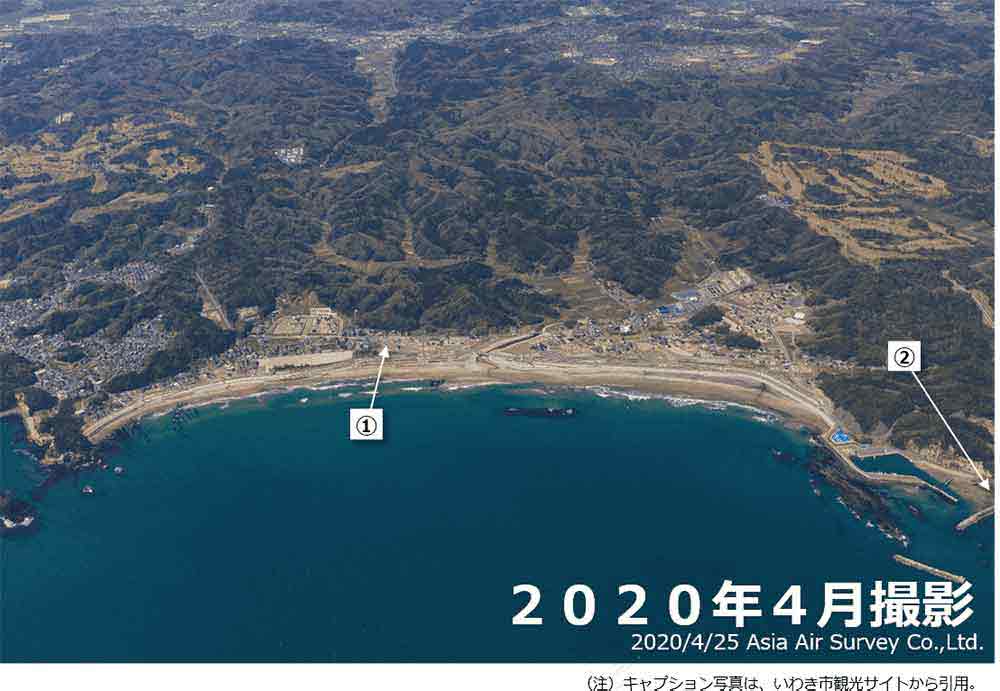
- Toyoma land readjustment project for earthquake recovery
- Area: 55.9 ha, Number of parcels: 349
Construction period: FY 2012 to FY 2018 - Shioyasaki Lighthouse
- Founded in 1899. 73 meters above sea level (23.6 meters high from the ground).
One of only 16 ""climbable lighthouses"" in Japan.
In addition to being the genesis of the film ""Times of Joy and Sorrow,"" a monument to Hibari Misora was erected at the base of the lighthouse.
Onahama Port, Iwaki City
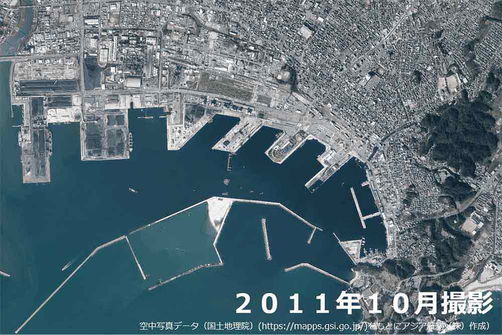
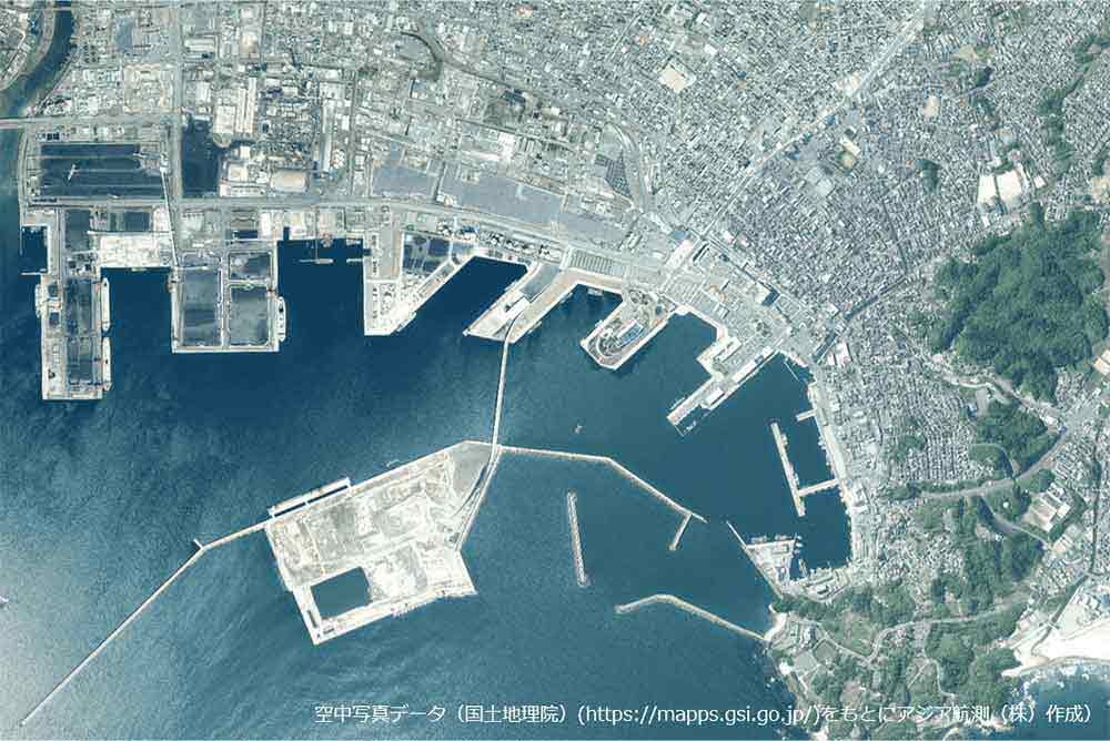
- Onahama Port
- The town prospered as a port for shipping rice to the shogunate in the Edo period and coal in the Meiji era. Since then, it has developed into an international trading port. At the time of the Great East Japan Earthquake, the magnitude of the quake was given as lower 6 intensity on the Japanese earthquake scale.
- Aquamarine Fukushima
- It was opened on July 15, 2000. Official name: ""Marine Science Museum, Fukushima Prefecture."" All buildings are barrier-free. One of the largest aquariums in the Tohoku region. It was closed on March 11, 2011 due to the Great East Japan Earthquake, but reopened on July 15, 2011. The theme of the aquarium is the ""tide line"" that appears on the coast of Fukushima Prefecture, and it displays more than 800 species. A 360-degree street view of Aquamarine Fukushima is also available (part of the museum is open to the public)."
- Iwaki Lalamew
- It opened on July 25, 1997 as a tourist and product center in Iwaki. It was closed due to the Great
East Japan Earthquake on March 11, 2011, but reopened on November 25 of the same year.
Live Iwaki Mew Jam on the second floor introduces various scenes of Iwaki through panels and videos. - Onahama land readjustment project for earthquake recovery
- Area: 12.2 ha,
Construction period: FY 2011 to FY 2018 - Onahama Fish Market
- On March 11, 2011, most of the buildings collapsed due to the Great East Japan Earthquake, but were rebuilt as part of the project to rebuild and improve fishery facilities in the Onahama region. It was completed and put into operation on March 26, 2015.
- Fukushima Fishery Oceanic Research Center
- It conducts tests and studies to promote the development of fisheries in coastal areas and the recovery of fisheries after the nuclear disaster.
- Iwaki Marine Tower
- Completed on August 1, 1986. An observation tower with a height of 59.99 m.
Iwama Area (east side), Iwaki City
- Iwama land readjustment project for earthquake recovery
- Area: 12.5 ha, Number of parcels: 59
Construction period: FY 2012 to FY 2018 - Obama land readjustment project for earthquake recovery
- Area: 3.8 ha, Number of parcels: 32
Construction period: FY 2013 to FY 2018
Iwama Area (west side), Iwaki City
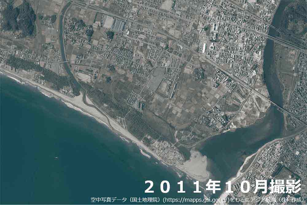
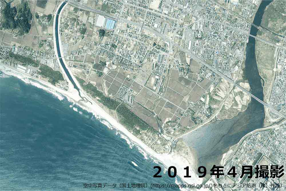
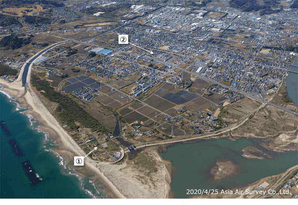
- Area: 4.0 ha, Target households: 40
Construction period: FY 2012 to FY 2018 - Area: 0.7 ha, Target households: 22
Construction period: FY 2012 to FY 2018 - Nishikimachi Suika collective relocation project for disaster prevention
- Area: 4.0 ha, Target households: 40
Construction period: FY 2012 to FY 2018

